
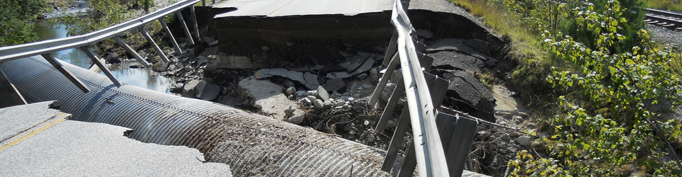
Reliable roads connect us to schools, our work and the people that sustain us. In the event of a natural disaster, roads allow the road crew to get to the equipment, first responders to arrive quickly, and allow us to secure food, shelter, and care.
Budgeting for roads requires careful annual work informed by your community’s capital program with an understanding of what’s worn out and what’s dangerous. In the event of a disaster, the loss of services can be devastating and the unbudgeted costs for repairs can be formidable.
Links to sections below:
- VTrans and Municipal Roads
- Transportation Inventory
- Rivers and Roads
- Roads, Regulations and Permits
- Technical Guidance for Stream Crossing Structures
- Planning for Reliable Roads
- More Resources
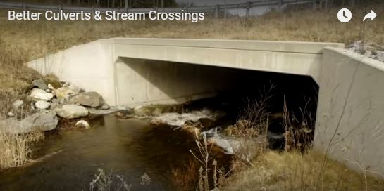
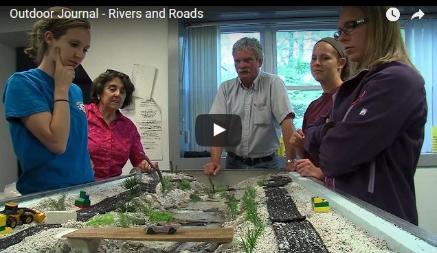
Video: Better Culverts & Stream Crossings
This video shows how communities can replace undersized culverts to provide reliable roads, reduce damage, reduce erosion rates and remove barriers to fish. This 13 minute video was produced by Riverbank Media for the Connecticut River Conservancy (CRC).
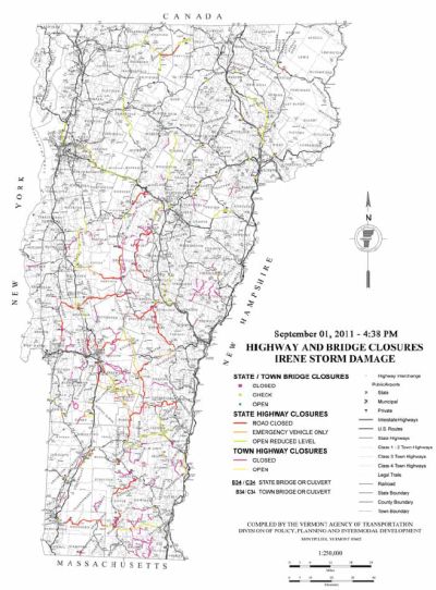
The map at right shows locations of federal Public Assistance grants for road and bridge damage through 2013.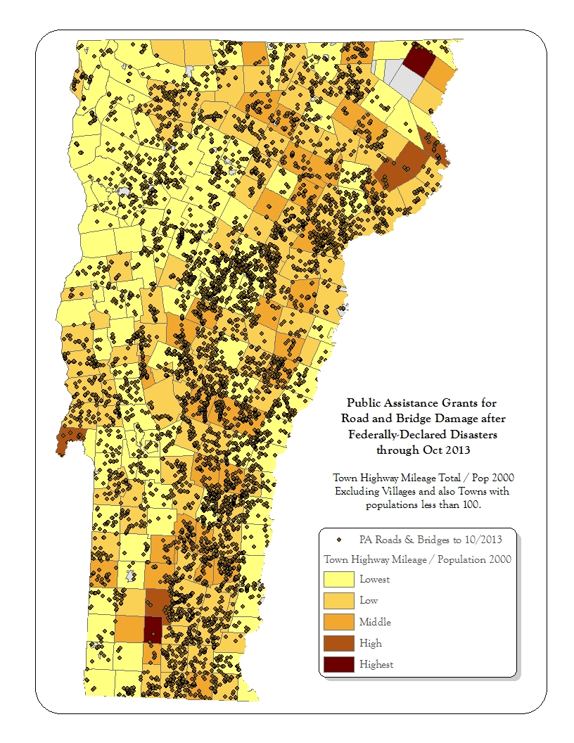
VTrans and Municipal Roads
VTrans provides critical services for municipalities including:
- Technical Assistance
- Town Highway and Structures Grants
- 2013 Road and Bridge Standards and Guidance
- Post-Disaster Assistance
- List of Adopted Municipal Road and Bridge Standards
- Training for Municipal Road Management
Communities that claim Town Highway Mileage are identified on the Municipal Road and Bridge Standards Report. The roads, culverts, and bridges of some places are managed by the Town or another Municipality. The Community Reports can also confirm what standards the community has adopted for road and bridge management. Communities that have adopted the 2013 Road and Bridge Standards as shown in the Orange Book: Handbook for Local Officials should be in accord with current stream crossing requirements. This will allow them to avoid confusion during the FEMA Public Assistance process, and satisfy one of the four flood mitigation actions needed to qualify for higher levels of post-disaster reimbursement through the Emergency Relief and Assistance Fund (ERAF).
Transportation Inventory
To qualify for a Town Highway Structures grant the community must have an inventory of highway infrastructure not more than three years old. The inventory should identify all town culverts, bridges, and known road problems. The inventory includes the location, size, deficiency/condition, and estimated cost of repair (where the condition is less than acceptable).
To support this effort VTrans maintains the Vermont Online Bridge and Culvert Inventory Tool.
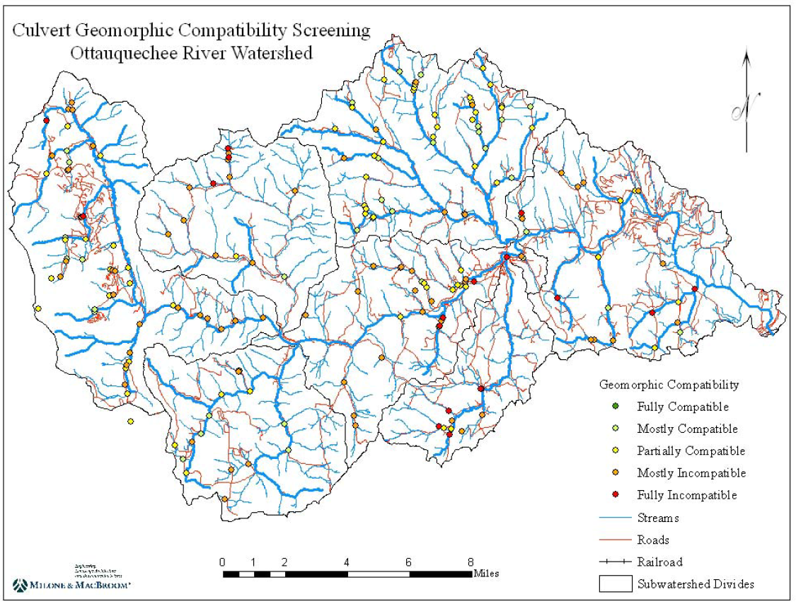
Some communities have completed additional assessments of bridges and culverts to identify whether they are geomorphically-compatible with the stream and if they present any barrier to the movement of fish and other aquatic life (Aquatic Organism Passage).
Vermont ANR Stream Geomorphic Assessment (SGA) Bridge and Culvert Export Table can summarize features such how much of the channel the structure blocks up (percent of bank-full width), how the structure may fail (and affect nearby roads), and how the structure affects aquatic life. The field names in the SGA Culvert Data are identified here.
If you need help – please contact the ANR River Scientist for your watershed.
The table below summarizes the situation in 2008 for culverts in the White River and Ottauquechee Watersheds. In the White River watershed five structures (one percent) were fully geomorphically-compatible.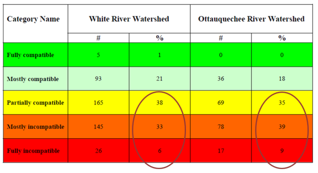
Use the Vermont ANR Stream Geomorphic Assessment (SGA) Bridge and Culvert Export Table to get data by community or watershed.
The geomorphic assessment data provides additional information on hazard priorities that can inform your Capital Program and Budget and Local Hazard Mitigation Plan.
If your community does not have geomorphic assessment data contact your Regional Planner to seek funds and contractual support.
Rivers and Roads
After Tropical Storm Irene it became clear that there was a need to train people working in or near rivers and streams. In response, VTrans and VT DEC have established a Rivers and Roads training sequence that has recently become available for municipal staff.
Tier One training and guidance booklets are on-line. The field-based Tier Two trainings are being scheduled by Vermont Local Roads (now with VTrans). In the future information on Rivers and Roads trainings for municipal staff may be posted by the VTrans Training Center.
Online training that provides a general awareness and understanding of river processes, aquatic habitat and how transportation infrastructure affects and is affected by river stability.
Intermediate Level – Tier Two
Classroom and field based training that focuses on accommodating channel stability and minimizing impacts to aquatic habitat in design, construction and maintenance of transportation infrastructure.
Vermont Rivers & Roads Field Manual (pdf 12,735 KB)
Rivers& Roads Manual in booklet form (pdf, 5,743 KB)
Roads, Regulations and Permits
Most in-channel management activities and new projects like bridges, culverts or utility crossings require regulatory action by the River Management Engineer. State jurisdictional thresholds and guidance on permit applications are provided within the documents below or by contacting the River Management Engineer in your area.
- Standard River Management Practice for Stream Crossing: Methods for examining river management alternatives and the most current river management practices based on the best available science and engineering methods
- Stream Alteration Permits: General and individual stream alteration permits regulate activities that take place in or along streams.
- Municipal Guide to Authorizing Instream Emergency Protective Measures in Vermont
- Municipally-Authorized Emergency Protective Measures: Activities authorized by the town to address an imminent threat to life or severe damage to property.
- Training video "Local Authorization of Emergency In-Stream Work"
- On-line Form to Request a River Management Engineer Site Visit, or to Report a Municipally-Authorized Emergency Protective Measure
- Emergency Protective Measures Tracking
A permit is required for movement, excavation, or fills involving 10 or more cubic yards annually in any perennial stream. See program Guidance for the Identification of Perennial Streams.
 Planning for Reliable Roads
Currently most road crossing structures are undersized leaving the transportation infrastructure ripe for injury, loss of emergency services and economic disruption.
To establish and maintain a reliable community transportation network will require:
1. Assessment of needs
Has your community adopted 2013 Road and Bridge Standards?
Do you have a current inventory of bridges and culverts with geomorphic data?
2. Prioritization
How are worn and hazardous transportation elements prioritized and scheduled for upgrade in your Capital Program and Budget and Local Hazard Mitigation Plan?
3. Leveraging funds to retrofit under-sized structures
Is the community able to qualify for VTrans Town Highway Structures and Bridge Program Grants, Better Roads Grants, or FEMA Hazard Mitigation Grants?
More Resources
- Orange Book:Handbook for Local Officials
- Vermont Standard River Management Principles and Practices
- VT ANR Stream Gravel Removal Policy (pdf, 260 KB)
- Gravel Removal: Historical Perspective and Current Practices (pdf, 386 KB)
- Impact Assessment of Instream Management Practices on Channel Morphology (pdf, 667 KB)
- Post-Disaster Funding and Assistance
- ACCD: Plan Today for Tomorrow’s Flood
- Vermont Economic Resiliency Initiative (VERI)