
River Corridors identify the area that the stream or river needs to maintain physical / geomorphic equilibrium. These dynamic areas are also where a great deal of damage occurs during flooding disasters. River Corridor data can be used along with Floodplain data to direct new structures to safer locations.
Links to sections below:
- What is a River Corridor?
- River Corridors - Frequently Asked Questions
- What is a Geomorphic Assessment?
- What is the Statewide River Corridor?
- Where can I learn more about River Policy, Data, Procedures, and Science?
What is a River Corridor?
A River Corridor includes the meander belt of a stream or river and a buffer of 50 feet. River Corridor as defined in Vermont statute: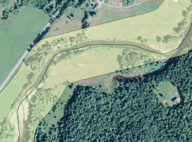
"River Corridor" means the land area adjacent to a river that is required to accommodate the dimensions, slope, planform, and buffer of the naturally stable channel and that is necessary for the natural maintenance or natural restoration of a dynamic equilibrium condition, as that term is defined in section 1422 of this title, and for minimization of fluvial erosion hazards, as delineated by the Agency of Natural Resources in accordance with river corridor protection procedures. 10 V.S.A. Chapter 32 § 752. Definitions
River corridors minimally encompass the meandering of a river in a least erosive form. They are drawn with the expectation that new and existing structures outside the corridor may be protected from lateral channel migration using bank stabilization practices without creating new or additional hazards. Within a river corridor, existing infrastructure and improved property may be at a heightened risk from erosion and be more likely to require river management to protect over time.
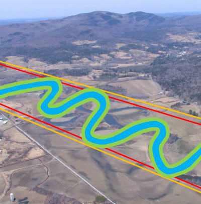 The river corridor includes both the channel and the adjacent land. The purpose of the zone is to identify the space a river needs to re-establish and maintain stable “equilibrium” conditions. In other words, if the river has access to floodplain and meander area within this corridor, the dangers of flood erosion can be reduced over time. River corridor maps are delineated based on scientific, location-specific assessment of the geomorphic (or physical) condition of a river. The Vermont Rivers Program has designed protocols to evaluate river conditions all over the state. The resulting data are used to map meander belt widths. One can think of this belt width as the particular “wiggle room” a river needs to find its most stable path down the valley, while efficiently moving and storing its sediment load. The shape and width of the meander belt varies with valley shape, surficial geology (e.g. bedrock, glacial lake sand), and the natural channel length, slope, and width. The lower the slope and the broader the valley, the more sinuous a river will likely be, in a natural setting. Rivers that have been historically straightened or encroached upon lose their natural stability when they lose their meanders and floodplain access. Given an appropriate amount of lateral space, an unstable river can eventually develop a stable meander pattern. Meanders may shift within the corridor over time, but the river will be less susceptible to dramatic channel adjustments and accelerated erosion.
In Vermont most flood-related damage occurs outside the Special Flood Hazard Areas. Much of the damage is due to the erosive power of water causing damage to critical public infrastructure such as roads and stream-crossings. Homes, businesses, and community buildings have also been damaged by flooding-related erosion. Where stream meanders are confined by human activity, streams lose their equilibrium and become steepened, straighter and more powerful. The more powerful the flooding stream the higher the risk for damage.
Corridors are the space in which streams and rivers WILL move, and corridor protection is the fundamental strategy by which we protect lives, property, water quality, habitat, and the economic value of our streams and rivers.
Chris Campany, Executive Director, Windham Regional Commisison Jan.2016
Today, most streams in Vermont are not in an equilibrium condition, because riverside development, channelization practices, and other historic land uses have prevented the river from assuming its most stable natural shape (meander pattern, slope, channel width and depth, sediment bars, etc.).
Vermont communities can choose to limit additional encroachment within the mapped River Corridor. Doing so can help streams lose flood energy in undeveloped areas and help prevent flood damage to existing riverside development from getting worse. While the River Corridor protects the stream’s ability to re-establish and maintain equilibrium,
On the other hand it is important to note that while the River Corridor protects the stream’s ability to establish and maintain equilibrium, the boundaries of the River Corridor do not predict where the stream will actually go. The River Corridor is not a predictive model and in response to existing encroachments and recent channelization practices most streams in Vermont are not in an equilibrium condition.
River Corridors include the area identified in many communities as the Fluvial Erosion Hazard Area (FEH). Many Vermont communities have secured Phase-2 Stream Geomorphic Assessment field data by which to identify and protect FEH areas.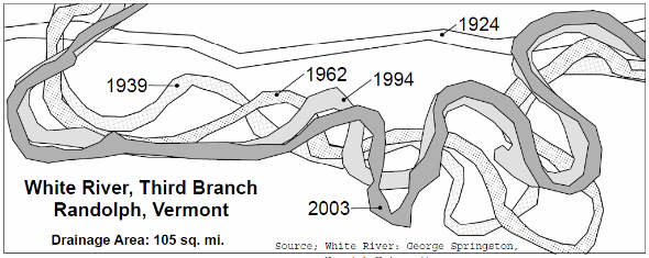
Why Protect River Corridors - Mike Kline 2/2016
What is a Geomorphic Assessment?
 Some communities have already secured funding for a field-based study of the physical condition of local rivers and major tributary streams. This process captures measurements of the channel, character of the stream bed, identifies exemplary reaches as well as sites where major physical changes are underway. A geomorphic assessment can sometimes include data on culverts and bridges to identify if they are geomorphically - compatible or if they are aggravating deposition and scouring. Using VT DEC protocols a Phase Two Fluvial Geomorphic Assessment would result in a River Corridor Plan and the identification of a Fluvial Erosion Hazard Area or River Corridor.
Existing Geomorphic Assessments and River Corridor Plans can be found online at Stream Geomorphic Assessment - Final Reports. If your community wants to pursue a field-based assessment contact your Regional Planning Commission or VT DEC River Scientist.
What is the Statewide River Corridor?
River Corridor data is available for the extent of the state. The data can be found on the Vermont Natural Resources Atlas The Statewide River Corridor includes rivers and streams with watersheds over two square miles. For small streams, with watersheds less than two square miles, the extent of the River Corridor is measured on the ground as fifty (50) feet from the top of the stream bank. The SRC of 1/2/2015 was developed using map-based data on watershed catchments, stream gradient, reference channel width, meander belt widths, valley walls, and major transportation features.
By creating a map-based SRC communities across the state will have a method to identify the areas needed to maintain geomorphic equilibrium and not displace and amplify the power of peak flows. Where communities have field based geomorphic studies the information on valley walls and channel characteristics may provide valuable information for the review of development proposals.
DEC River Scientists have recently updated the SRC with available Phase 2 fluvial geomorphic data and has been posted on the ANR Natural Resources Atlas and the Vermont Flood Ready Atlas
For more information on River Corridor maps and GIS access.
Where can I learn more about River Policy, Data, Procedures, and Science?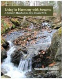
Reading Vermont’s Rivers, VNRC 2013
Living in Harmony with Streams: A Citizen’s Handbook to How Streams Work, Friends of the Winooski, 2012
River Corridors - Frequently-Asked-Questions (FAQ)
Resources - River Science and Policy
The Vermont Flood Hazard Area & River Corridor Protection Procedure
Protecting River Corridors in Vermont. Kline, Michael and Barry Cahoon, 2010. Journal of the American Water Resources Association (JAWRA) 1-10
River Corridor Plans and Geomorphic Assessments
Publications on River Corridors
The current model regulations address Special Flood Hazard Areas and River Corridors. Contact a DEC Regional Floodplain Manager if you would like a Word version of the model to work with. The model bylaws are available for communities that have zoning as well as for communities that will adopt the text as a stand-alone bylaw.