
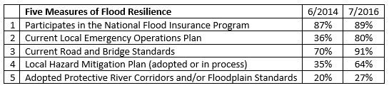
Since 2011 most communities across Vermont have taken important steps to become more flood resilient. Over a quarter of Vermont communities have protected river corridors or floodplains from further losses. Over half have Local Hazard Mitigation Plans adopted or in process (up from 35% in 2014), and 80% have Emergency Operations Plans in place (up from 36% in 2014).
The Flood Ready Vermont website www.floodready.vermont.gov was launched in July 2014 and features Community Reports, a Flood Resilience Listserve, peer stories from community efforts around the state and access to information for planning, training and grants.
River corridor maps have been available state wide since January 2015 and posted on the Flood Ready Atlas tinyurl.com/floodreadyatlas . When river corridors (the room needed by streams and rivers) are not protected, the high flows can become increasingly powerful and damaging. Vermont municipalities, regions and state agencies have the shared goal of river corridor protection for flood resilience. Contact your Regional Floodplain Manager for more information.
Since October 2014 the Vermont Emergency Relief and Assistance Fund has benefited communities that take specific steps to reduce flood damage. The majority of Vermont municipalities now qualify for additional State aid to supplement federal Public Assistance after a disaster.
The Agency of Commerce and Community Development has developed numerous planning resources for municipal officials at Plan Today for Tomorrow’s Flood and has worked closely with five communities around the state through the Vermont Economic Resilience Initiative.
Many non-governmental organizations including watershed organizations, land trusts, regional planning commissions, conservation districts, the Lake Champlain Basin Program, the Lake Champlain Committee, Resilient Vermont, the UVM Lake Champlain Sea Grant program, the Vermont League of Cities and Towns and the High Meadows Fund have been supporting community work for flood resilience. Some of this work has been captured as stories at “Making it Happen” or listed on the Resources page at Flood Ready Vermont.
Municipal Officials can access an up-to-date Expanded Community Report and Regional Summaries at Flood Ready Vermont.
Additional resources including information about Municipally Authorized Emergency Protective Measures and Rivers and Road Training for Municipal Road Workers are available on the VT DEC Rivers webpages: dec.vermont.gov/watershed/rivers