Maps are a helpful tool for integrating and displaying important information about your community: this case, its watersheds, rivers, floodplains and river corridors. Understanding these features and how their presence and locations affect your community can help you update your plans and make the right investments. Where does existing development encroach into river corridors? What hazards exist? Where are the safer places to direct future growth?
Links to sections below:
What is mapped?
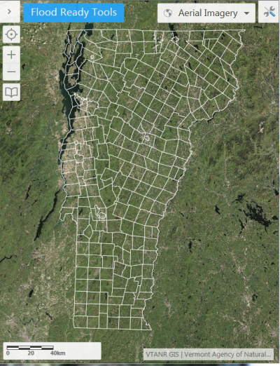
On the Vermont Flood Ready Atlas bit.ly/floodatlas you can find:
- Communities that participate in the National Flood Insurance Program
- Communities with Local Emergency Operations Plans
- Making it Happen (work by communities on flood resilience)
- Flood Hazard Mapping (what type of digital flood data is available)
- River Corridors
- Special Flood Hazard Areas (both officially digitized by FEMA and non-official/rough data)
- Watershed boundaries and topography
- Lakes and rivers
- Forested areas and wetlands
- Critical transportation routes, bridges, and culverts
- Critical facilities (including schools, fire, police, ambulance, town buildings, road maintenance garages, emergency shelters, wastewater plants, public water sources, etc.)
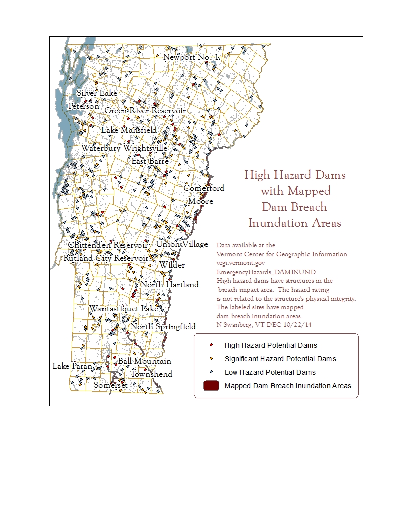
- High hazard dam locations
Special Flood Hazard Areas are mapped by FEMA and indicate areas with a 1% or greater annual chance of flooding. Over the 30-year period of a mortgage this represents more than a one in four chance. On the Vermont Flood Ready Atlas, only Special Flood Hazard Areas that have been officially digitized by FEMA are displayed. These areas are shown on "Digital Flood Insurance Rate Maps". In some areas you will need to find the data from other sources such as the FEMA Map Service Center.
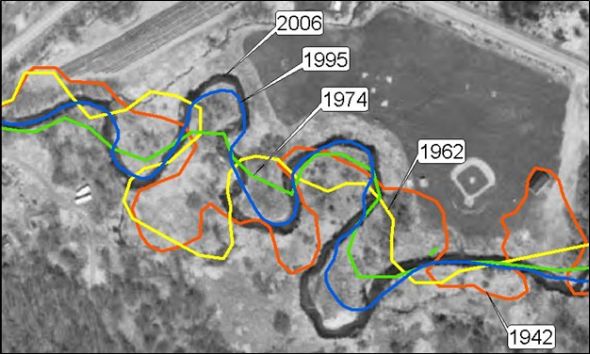
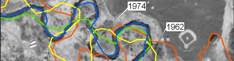
River Corridors are areas where streams and rivers respond physically to their loads of water, sediment, and debris. The Vermont Department of Environmental Conservation has prepared statewide maps of river corridors. The statewide river corridors maps are available online at the Vermont Flood Ready Atlas
How to use what you find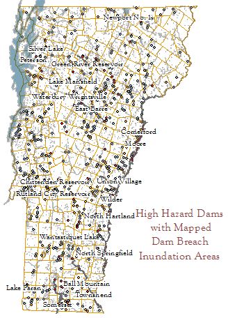
The map data, together with your expanded community report will help you identify:
Where does water and its energy move through your community?
- Do your streams and rivers have room to adjust to their loads of water, energy, sediment and debris?
- What hillsides contribute water and energy to the streams? Are they forested and capable of slowing down the water?
Where are safer locations for the future development of the community?
- What areas are exposed to flooding?
- What areas are less likely to conflict with your rivers and streams?
What infrastructure is at risk of flood damage?
- Are there undersized culverts? Prioritize replacement of the culverts under your most important roads.
- Are your bridges adequately supported for high waters?
What buildings are at risk of flood damage?
- Can they be moved?
- Can they be improved to better withstand flooding?
- Are they insured?
Most of this information can be found using the online map tools presented below. Other kinds of data may need the support of a computer GIS map analysis from the regional planning commission.
Useful map sites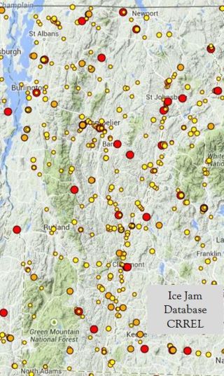
Vermont Flood Ready Atlas - Digital Flood Insurance Rate Map (DFIRM) Flood Hazard Areas, Floodways, Dams, E911 Sites, Wetlands. Also look under “Rivers Management Theme” for additional river assessment data. bit.ly/floodatlas
Also see Map Data under Resources
FEMA Map Service Center - DFIRM and non-digitized Flood Hazard Areas, Floodways
Flood Map Changes Viewer (to see Preliminary and Effective Digital FIRM data).
USGS Stream Stats - Watershed areas, flood discharge estimates, some information on landcover
NWS Significant Flood Outlook
Northeast River Forecast Center
NWS Advanced Hydrologic Prediction Service
NWS Burlington (Northern Vermont)
NWS Albany (Southern Vermont)
NOAA Interactive Snow Information
Google Crisis Map - Weather and Events
CRREL Ice Jam Database
VTrans Online Bridge and Culvert Inventory Tool
VT DEC Stream Geomorphic DMS Bridge and Culvert Database
Vermont Center for Geographic Information
VCGI Interactive and Static Maps
VCGI Irene Data
VT DEC Water Quality Tactical Basin Planning
VTrans Reducing Repeat Damage Mapping Tool
USGS WaterWatch
USGS RealTime Stream Flows
USGS Data and Tools
USGS StreamStats for Vermont
USGS National Climate Change Viewer
VT DEC River Corridor Plans and Final Reports
Vermont Geological Survey Stream Geomorphology
National Register of Historic Places ACCD
NWS Advanced Hydrologic Prediction Service - Inundation Mappers
Two specialized Flood Inundation Mappers have been established by NOAA/NWS:
These web-based maps identify the areas inundation at different levels of predicted precipitation and discharge:
Some data can be mapped – but it is not available online. You may want to work with a GIS professional at your Regional Planning Commission to locate this data on a map.
Also, some data has been already analyzed and you can find it on the Community Reports page or from the Resources page.