
A floodplain is the area affected by water that has extended beyond the normal banks of a stream, river, pond, or lake. Floodplains provide important social, economic and ecological functions. Floodplains are also places where people, human structures and critical transportation infrastructure can be vulnerable to disruption and damage. Since floodplains are also a key part of the National Flood Insurance Program these areas have a number of specific technical terms that are important.
Links to sections below:
- Floodplain Services
- Mapped Floodplains
- Flood Hazard Zones
- How Floodplains Are Mapped
- Key Terms
- Resources
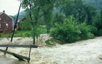
The amount of water in the stream changes constantly, but every year or two, high flows will exceed the capacity of the channel and water will flow over the banks onto the adjacent land. A stream in good condition should experience many such smaller floods and fewer larger floods. In areas that get routinely flooded during the growing season very specific kinds of shrubs and trees will be able to survive.
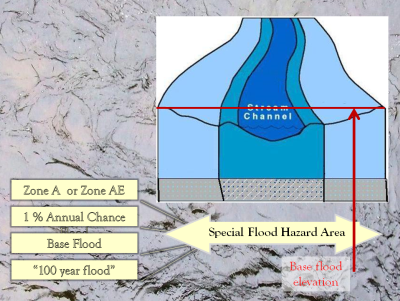
The National Flood Insurance Program (NFIP) is set up around a specific size flood with a one percent chance each year. This size event is known as the “base flood” of the NFIP and forms the basis of the insurance program. The extent of this flood event is identified on Flood Insurance Rate Maps as Zone A, AE, A1- A30, or AO. Along some rivers with detailed studies the extent of the 0.2% (or 500 year flood) may be identified.
When a lake is in flood stage the water will extend beyond the normal banks onto adjacent low areas. The effect of lake shore flooding can also be increased by waves and sometimes by the gradual sloshing of the water (seiche) across the extent of the lake after a storm front.
Floodplain Services
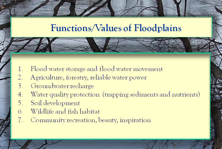
Floodplains provide multiple functions that are important to society.
- Floodplains provide a place for excess water to be and to move through the landscape. When we know where these floodplains are we can stay safely out of the way;
- Floodplains that retain and slow floodwater reduce the peak of flows and the erosive damage downstream;
- Floodplains provide opportunities for groundwater recharge and often occur in locations with significant aquifers.
- Floodplains allow the milk-chocolate water to slow down and to deposit sediments, rather than carrying the phosphorus-laden material into ponds, lakes, and estuaries downstream;
- The sediments deposited on floodplains build soil including some of our richest prime agricultural floodplain soils;
- The floodplains of rivers are often very productive sites for agriculture and forestry;
- Floodplains adjacent to streams, wetlands and uplands provide exceptional habitat resources for aquatic and terrestrial life;
- Floodplains support the clean water for the lakes and rivers that our communities value.
Mapped Floodplains
The National Flood Insurance Program provides Flood Insurance Rate Maps (FIRMs) and Flood Hazard Boundary Maps . In some locations there may be additional relevant studies available from the US Geological Survey, Natural Resources Conservation Service, or the Army Corps of Engineers. If you are aware of a separate study check your municipal office for a copy or check with your ANR Floodplain Manager.
You can find mapped floodplains at the FEMA Map Service Center. Officially digitized “DFIRMS” are also available on the Vermont Flood Ready Atlas.
Flood Hazard Zones
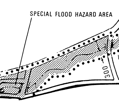
 The Flood Insurance Rate Map (FIRM) shows the extent of the “Base Flood” (the area of inundation that is the basis for the insurance program). The area of the base flood is regulated by the community as the legal “Special Flood Hazard Area” (SFHA).
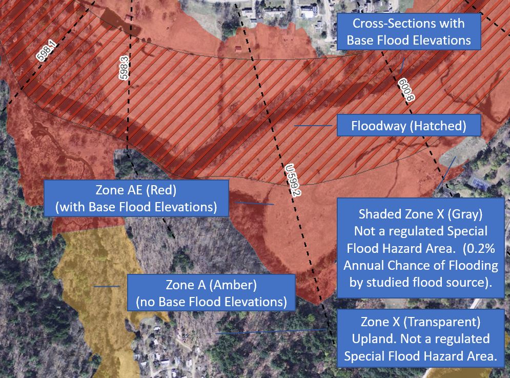
On the Flood Insurance Rate Map the Special Flood Hazard Area may be shown as a Zone A, Zone AE, Zone A 1 – A30, Zone or Zone AO in Vermont. Within areas with detailed studies (Zone AE or Zone A1 - A30) the community may have a mapped Floodway. In some communities the extent of the Floodway may be shown on a separate map panel. Floodway Maps, where separate, can be found under "All Products" on the FEMA Map Service Center. Floodways identify an area that can convey the base flood without raising the level of the water more than a foot. This area has a higher level of protection and is roughly where the fastest and most powerful flow occurs.
Beyond the Special Flood Hazard Area other mapped flood zones may include Zone X (shaded), or Zone B – two names for moderate risk areas with a 0.2% annual chance of flooding (from the studied sources); and Zone X or Zone C – two names for more upland areas with minimal risk of flooding from a studied stream.
Much of the damage experienced during storm events in Vermont is in Zone X !
How Floodplains Are Mapped
 For the purposes of the National Flood Insurance Program the scientific, technical, and public process to map a floodplain follows from the Code of Federal Regulations in 44 CFR 65.
The first maps for the NFIP were created in the 1970s and used a mix of detailed and approximate methods. Communities that received a detailed study (providing base flood elevations and floodway data) would also receive a Flood Insurance Study identifying how the maps were prepared and supplementary data including flood profiles. Flood Insurance Studies and Historic Maps can be found under "All Products" on the FEMA Map Service Center.
In 2004 FEMA was funded to begin a nationwide update of flood hazard maps to digitize the maps and bring the program into the computer age. In Vermont the Map Modernization Program (MMMS) created Digital Flood Insurance Rate Maps (DFIRM) on a county-wide basis for Windham, Windsor, Rutland, Washington and Chittenden and Bennington Counties.
In 2017 FEMA began statewide map updates using the RiskMAP program. This approach studies flood risk watershed by watershed at a HUC-8 scale (equivalent to the watersheds of Otter Creek, the West River or the Passumpsic). The work has been supported by the high quality topography from lidar now available across Vermont.
To map the extent of the base flood with a detailed method it is necessary to have:
- Topography – information about watersheds, valley cross-sections, and channel cross-sections;
- Hydrology – information about water and the size and frequency of peak flows; and
- Hydraulics – to model how and where the liquid will move through the landscape.
The Guidelines and Standards for Flood Risk Analysis and Mapping describe the technical standards and process.
For up to date information about the FEMA map update process please visit Flood Training: bit.ly/fema-map-update
Key Terms
- Base Flood Elevation (BFE)
- FEMA Acronyms Abbreviations and Terms (FAAT Book)
- Flood Insurance Rate Map (FIRM)
- Flood Insurance Study (FIS)
- Flood or Flooding
- Flood Zones
- Floodway
- National Flood Insurance Program (NFIP)
- Risk Rating 2.0
- Special Flood Hazard Area (SFHA)
- Stage – The local depth of water in the channel
- More River Terms and Speaking of Rivers
Resources
- Information on the current flood map updates: bit.ly/fema-map-update
- Advanced Hydrologic Prediction Service – NOAA/National Weather Service (for Waterbury, VT)
- Connecticut River Watershed Atlas – USG
- Flood Ready Atlas – ANR Natural Resource Atlas
- Map Service Center – Flood Insurance Rate Maps FEMA/ NFIP
- National River and Flood Observations and Forecast – NOAA/ NWS USGS
- Significant River Flood Outlook NOAA/ NWS
- Northeast River Forecast Center NOAA/ NWS
- Storm Prediction Center NOAA/ NWS
- StreamStats in Vermont USGS
- Water Resources of the United States USGS
-
The current model regulations address Special Flood Hazard Areas and river corridors. Contact a Floodplain Manager if you would like a Word version of the model to work with. The model bylaws are available for communities that have zoning as well as for communities that will adopt the text as a stand-alone bylaw.