
Scroll down through the list or use Ctrl + F to find a term on this page using your browser.
Below are definitions for terms that are used in discussions about rivers, floodplains, river corridors and fluvial geomorphology (the study of physical processes in rivers).
Jump to letter D, Jump to letter L, Jump to letter S
Some terms are adapted from the National Flood Insurance Program as listed in 44 CFR 59.1 and/or can be found in Vermont statute, or in model bylaws available from VT DEC.
More information can be found at the VT DEC Rivers Program webpages and www.floodready.vt.gov .
“Accessory Dwelling” means an efficiency or 1-bedroom apartment that is located within or appurtenant to an owner-occupied house, and is clearly subordinate to the owner-occupied house. The Accessory Dwelling includes all the amenities needed for independent living, such as for sleeping and food preparation, and has the capacity to handle additional wastewater/water supply demand, is limited in size to the owner-occupied house. See 24 V.S.A.§4412(1)(E) for more information. Back to Top
“Accessory Structure” means a structure which is: 1) detached from and clearly incidental and subordinate to the principal use of or structure on a lot, 2) located on the same lot as the principal structure or use, 3) clearly and customarily related to the principal structure or use, and 4) only used for vehicle parking, storage or primarily building access. For residential uses these examples include, but may not be limited to garages, garden and tool sheds, and playhouses. An Accessory Dwelling is not an Accessory Structure. but it would not include a secondary residence. Back to Top
“Aggradation” means the buildup of sediment in the channel. Back to Top
"Aggrading Channel Bed" means the deposit of instream materials and a raising of the channel bed elevation that occurs at the reach scale with a decrease in stream power, brought about by a change in channel dimensions, slope, and/or roughness characteristics. Back to Top
“Alluvial Fan” means an area where large deposits of sediment often form. This often occurs where there is an abrupt change from a steep eroding stream reach to a flat depositional reach. Back to Top
"Annual Flood" means a flood flow event that occurs at a high frequency, i.e., there is a greater than a 50% chance of a flood stage (Q 1.5) of at least this level occurring in any given year. Back to Top
"Aquatic Life" means all organisms that, as a part of their natural life cycle, live in or on waters. Aquatic life is synonymous with "Aquatic Biota" as defined in Vermont Water Quality Standards. Back to Top
Aquatic Organism Passage (AOP) – stream channel conditions that allow fish and other aquatic organisms to move freely up and down stream. Culverts at road crossings sometimes cause barriers to AOP. Back to Top
“Area of Special Flood Hazard” is synonymous in meaning with the phrase “special flood hazard area” for the purposes of these regulations. Back to Top
Armored - describes a bank that has been protected against erosion by the addition of large rock (rip rap) or concrete walls. Back to Top
“Associated transportation and utility networks” means those transportation and utility networks connected to a bridge, culvert, or utility for the purpose of crossing a river or stream and do not include transportation or utility networks within the river corridor that merely run parallel to a river or stream. Back to Top
Avulsion occurs when the stream channel establishes a wholly new path Back to Top
"Banks" means that land area immediately adjacent to the bed of the stream, which is essential in maintaining the integrity thereof. Back to Top
Bank full flows occur when the stream or river (barely) overtops its banks. This flow occurs, on average, about once every 1 to 2 years. Back to Top
"Bank full Width" means the top surface width of the stream channel at a discharge corresponding to a water stage that occurs at a frequency of every 1 to 2 years (Ql.5 to Q2, i.e., there is a 50 to 66% chance of this high flow occurring in a given year). Bank full widths are measured from the crest of the right stream bank to the crest of the left stream bank for streams in equilibrium condition, from field scour and deposition indicators of bank full stage for incised channels, or, when field measurements are not available, as calculated from reference data such as the Vermont Hydraulic Geometry Curves
“Base Flood” means the flood having a one percent chance of being equaled or exceeded in any given year (commonly referred to as the “100-year flood”). Back to Top
“Base Flood Elevation” (BFE) is the elevation of the water surface elevation resulting from a flood that has a 1 percent chance of equaling or exceeding that level in any given year. On the Flood Insurance Rate Map the elevation is usually in feet, in relation to the National Geodetic Vertical Datum of 1929, the North American Vertical Datum of 1988, or other datum referenced in the Flood Insurance Study report, or the average depth of the base flood, usually in feet, above the ground surface. Back to Top
“Basement” means any area of a building having its floor elevation below ground level on all sides, including crawlspaces. Back to Top
"Bed" means the maximum area covered by waters of the stream for not less than 15 consecutive days in one year. Back to Top
"Berm" means a linear fill of earthen material on or adjacent to the bank of a watercourse that constrains waters from entering a flood hazard area or river corridor, as those terms are defined in subdivisions 752(3) and (11) of this title. Back to Top
“BFE” see Base Flood Elevation Back to Top
“Buffer” means an undisturbed area consisting of trees, shrubs, ground cover plants, duff layer, and generally uneven ground surface that extends a specified distance horizontally across the surface of the land from the mean water level of an adjacent lake or from the top of the bank of an adjacent river or stream. Back to Top
“Channel” means an area that contains continuously or periodic flowing water that is confined by banks and a streambed. Back to Top
"Channel Evolution" is the process of of stream channels adjust to changes in the amount of water and sediment over time. These are described as a sequence of stages.
"Channelized" means the condition of a stream channel that has been straightened, bermed, dredged, and/or armored by human activity. Back to Top
"Channel Incision" means an area of stream bed exhibiting vertical erosion or headcutting. Back to Top
"Channel Roughness" means the frictional resistance, and its moderating effect on flow velocities, provided by: the sizes of instream material on stream beds and banks (i.e., channel boundaries); the undulations of stream bed forms; and the sinuous features along the channel planform. Back to Top
“Compensatory storage” means a volume not previously used available for flood storage and which shall be incrementally equal to the theoretical volume of flood water at each elevation, up to and including the base flood elevation, which would be displaced by the proposed project. Such compensatory volume shall have an unrestricted hydraulic connection to the same waterway or water body. Further, with respect to waterways, such compensatory volume shall be provided within the same reach of the river, stream, or creek. Back to Top
“Common plan of development” is where a structure will be refurbished over a period of time. Such work might be planned unit by unit. Back to Top
“Construction trailer” means a vehicle which is: (1) built on a single chassis; (2) 500 square feet or less when measured at the largest horizontal projection; (3) designed to be self-propelled or permanently towable; and (4) designed for use as a temporary office facility used to support managing a construction project, and not as a permanent structure. Back to Top
“Critical facilities” - include police stations, fire and rescue facilities, hospitals, shelters, schools, nursing homes, water supply and waste treatment facilities, and other structures the community identifies as essential to the health and welfare of the population and that are especially important following a disaster. For example, the type and location of a business may raise its status to a Critical Facility, such as a grocery or gas station. Back to Top
"Dam" applies to any artificial structure on a stream or at the outlet of a pond or lake, which is utilized for holding back water by ponding or storage together with any penstock, flume, piping or other facility for transmitting water downstream to a point of discharge, or for diverting water from the natural watercourse to another point for utilization or storage. Back to Top
"Degrading Channel Bed" means the erosion of instream bed materials and a lowering of the channel bed elevation that occurs at the reach scale with an increase in stream power, brought about by a change in channel dimensions, slope, and/or roughness characteristics. Back to Top
“Designated center” means a downtown, village center, new town center, growth center, or neighborhood development area designated pursuant to 24 V.S.A. chapter 76A. Back to Top
“Development” means any human-made change to improved or unimproved real estate, including but not limited to buildings or other structures, mining, dredging, filling, grading, paving, excavation or drilling operations, or storage of equipment or materials. Back to Top
"Dredge" means lowering the elevation of the stream bed profile or any clearing, deepening, widening, or excavating, either temporarily or permanently. Back to Top
Elevation Certificate (EC) – documents how high the lowest floor of the house is above the flood water. Back to Top
"Equilibrium condition" means the width, depth, meander pattern, and longitudinal slope of a stream channel that occurs when water flow, sediment, and woody debris are transported by the stream in such a manner that it generally maintains dimensions, pattern, and slope without unnaturally aggrading or degrading the channel bed elevation. Back to Top
Equilibrium slope – a stream that is not steeper and more erosive than under natural conditions. Back to Top
“Fill” means any placed material that changes the natural grade, increases the elevation, redirects the movement of flood water, or diminishes the flood storage capacity at the site. Back to Top
“Flood” means (a) a general and temporary condition of partial or complete inundation of normally dry land areas from: the overflow of inland or tidal waters; the unusual and rapid accumulation or runoff of surface waters from any source; and mudslides which are proximately caused by flooding and are akin to a river of liquid and flowing mud on the surfaces of normally dry land areas, as when earth is carried by a current of water and deposited along the path of the current. (b) The collapse or subsidence of land along the shore of a lake or other body of water as a result of erosion or undermining caused by waves or currents of water exceeding anticipated cyclical levels or suddenly caused by an unusually high water level in a natural body of water, accompanied by a severe storm, or by an unanticipated force of nature, such as flash flood or abnormal tidal surge, or by some similarly unusual and unforeseeable event which results in flooding. Back to Top
"Flood Flowage" means any waters, sediment, and debris associated with a high discharge or flood flow event (Ql.5 or greater). Back to Top
“Floodplain” means any land area susceptible to being inundated by water from any source (see definition of “Flood”). Back to Top
“Flood Fringe” means the area that is outside of the floodway but still inundated by the designated base flood (the flood having a one percent chance of being equaled or exceeded in any given year). Back to Top
“Flood hazard” means those hazards related to inundation damages from inundation. Back to Top
"Flood Hazard Area" means the land in the flood plain within a community subject to a 1 percent or greater chance (QIOO) of flooding in any given year. Back to Top
“Flood Insurance Rate Map” (FIRM) means an official map of a community, on which the Federal Insurance Administrator has delineated both the special flood hazard areas and the risk premium zones applicable to the community. In some communities the hazard boundaries are available in paper, pdf, or Geographic Information System formats as a Digital Flood Insurance Rate Map (DFIRM). Back to Top
“Flood Insurance Study” means an examination, evaluation and determination of flood hazards and, if appropriate, the corresponding water surface elevations or an examination, evaluation and determination of mudslide (i.e., mudflow) and /or flood related erosion hazards. Back to Top
“Floodplain or flood-prone area” means any land area susceptible to being inundated by water from any source (see definition of “flood”). Back to Top
"Floodplain Connectivity" means that geomorphic condition in which flows, at or greater than the annual flood stage (Ql.5), will spill out of the stream channel and onto the floodplain. Back to Top
“Flood proofing” means any combination of structural and non-structural additions, changes, or adjustments to structures which reduce or eliminate flood damage to real estate or improved real property, water and sanitary facilities, structures and their contents. Back to Top
“Floodway” means the channel of a river or other watercourse and the adjacent land areas that must be reserved in order to discharge the base flood without cumulatively increasing the water surface elevation more than one foot at any point. Please note that Special Flood Hazard Areas and floodways may be shown on a separate map panels. Back to Top
"Fluvial erosion" means the erosion or scouring of riverbeds and banks during high flow conditions of a river. Back to Top
"Fluvial Erosion Hazards" means those hazards to public safety or property related to the erosion or scouring of streambeds and banks during high flow conditions of a river.
“Functionally dependent use” means a use which cannot perform its intended purpose unless it is located or carried out in close proximity to water. Back to Top
"Geomorphic condition" means the degree of departure from the dimensions, pattern, and profile associated with a naturally stable channel representing the unique dynamic equilibrium condition of a river segment. Back to Top
"Geomorphic Sensitivity" means the potential of a river, given its inherent characteristics and present geomorphic conditions, to be subject to a high rate of fluvial erosion and other river channel adjustments, including erosion, deposit of sediment, and flooding. Back to Top
“Grading” means the movement or replacement of topsoil or other material that already exists on the site and located originating on the site and within the hazard area. Grading resulting results in minor or no changes in topographic elevations. This Grading also includes the replacement of unsuitable material of an equal or lesser volume that already exists within the hazard area, as long as the replacement material does not originate outside of the hazard area and its placement does not result in a significant change in ground elevation. It does not mean the import of material from the same parcel but located outside of the hazard area, which would be considered filling. Back to Top
"Hazard area" means land subject to landslides, soil erosion, fluvial erosion, earthquakes, water supply contamination, or other natural or human-made hazards as identified within a "local mitigation plan" enacted under section 4424 of this title and in conformance with and approved pursuant to the provisions of 44 C.F.R. § 201.6. Back to Top
"Headcutting" means the erosive process of stream bed particles being washed off a steepened area of a stream bed, deepening the channel and resulting in a loss in vertical and floodplain connectivity. Back to Top
“Historic structure” means any structure that is: (a) listed individually in the National Register of Historic Places (a listing maintained by the Department of the Interior) or preliminarily determined by the Secretary of the Interior as meeting the requirements for individual listing on the National Register; (b) certified or preliminarily determined by the Secretary of the Interior as contributing to the historical significance of a registered historic district or a district preliminarily determined by the Secretary to qualify as a registered historic district; (c) individually listed on a state inventory of historic places in states with historic preservation programs which have been approved by the Secretary of the Interior; or (d) individually listed on a local inventory of historic places in communities with historic preservation programs that have been certified either: (i) by an approved state program as determined by the Secretary of the Interior or (ii) directly by the Secretary of the Interior in states without approved programs. Back to Top
"Hydrologic Regime" means the timing, volume, and duration of flow events throughout a defined period of time, which may be influenced by the climate, soils, geology, groundwater, watershed land cover, connectivity of the stream, riparian, and floodplain network, and valley and stream morphology. Back to Top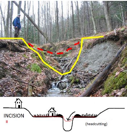
"Incision" is a stage of stream channel evolution where the channel becomes deeper.
“Infill development” means, for the purposes of designated centers, construction, installation, modification, renovation, or rehabilitation of land, interests in land, buildings, structures, facilities, or other improvements in an area that was not previously developed but is surrounded by existing development. For the purposes of farm production areas, infill development means construction on a vacant area within the farm production area. Back to Top
"Instream material" means: (A) all gradations of sediment from silt to boulders; (B) ledge rock; or (C) large woody debris in the bed of a watercourse or within the banks of a watercourse. Back to Top
"Intermittent Stream" means a seasonal stream that only flows for part of the year.
"Large woody debris" means any piece of wood within a watercourse with a diameter of 10 or more inches and a length of 10 or more feet that is detached from the soil where it grew. Back to Top
“Letter of Map Change (LOMC)” is a letter issued by the Federal Emergency Management Agency officially removing a structure or lot from the flood hazard zone based on information provided by a certified engineer or surveyor. This is used where structures or lots are located above the base flood elevation and have been inadvertently included in the mapped special flood hazard area. A LOMC can include a Letter of Map Amendment (LOMA), Letter of Map Revision (LOMR), Letter of Map Revision based on Fill (LOMR-F) or a Letter of Map Revision for a Floodway (LOMR-FW) Back to Top
"Longitudinal Stream Bed Profile" means the slope or vertical drop of the stream bed from upstream to downstream in relationship to adjacent floodplain features. Back to Top
“Lowest floor” means the lowest floor of the lowest enclosed area (, including basement). , except aAn unfinished or flood resistant enclosure, usable solely for parking of vehicles, building access or storage in an area other than a basement area is not considered a building’s lowest floor; provided that such enclosure is not built so as to render the structure in violation of the applicable non-elevation design requirements of 44 CFR 60.3. Back to Top
“Manufactured home (or Mobile home)” means a structure, transportable in one or more sections, which is built on a permanent chassis and is designed for use with or without a permanent foundation when attached to the required utilities. The term “manufactured home” does not include a “recreational vehicle”. Back to Top
"National Flood Insurance Program" means the National Flood Insurance Program under 42 U.S.C. chapter 50 and implementing federal regulations in 44 C.F.R. parts 59 and 60. Back to Top
“New construction” for regulation under this bylaw, means structures for which the start of construction commenced on or after the effective date of the floodplain management regulation adopted by the community and includes any subsequent improvements to such structures. Back to Top
"Nonconforming structure" means a structure or part of a structure that does not conform to the present bylaws but was in conformance with all applicable laws, ordinances, and regulations prior to the enactment of the present bylaws, including a structure improperly authorized as a result of error by the administrative officer. Structures that were in violation of the flood hazard regulations at the time of their creation, and remain so, remain violations and are not nonconforming structures. Back to Top
“Nonconforming use" means use of land that does not conform to the present bylaws but did conform to all applicable laws, ordinances, and regulations prior to the enactment of the present bylaws, including a use improperly authorized as a result of error by the administrative officer. Back to Top
"Nonconformity" means a nonconforming use, structure, lot, or parcel. Back to Top
“Non-residential” includes, but is not limited to: small business concerns, churches, schools, nursing homes, farm buildings (including grain bins and silos), pool houses, clubhouses, recreational buildings, government buildings, mercantile structures, agricultural and industrial structures, and warehouses. Back to Top
"Perennial Stream" means a watercourse or portion, segment, or reach of a watercourse, generally exceeding 0.5 square miles in watershed size, in which surface flows are not frequently or consistently interrupted during normal seasonal low flow periods. Perennial streams that begin flowing subsurface during low flow periods, due to natural geologic conditions, remain defined as perennial. All other streams, or stream segments of significant length, shall be termed intermittent. A perennial stream shall not include the standing waters in wetlands, lakes, and ponds. Back to Top
“Public water access” means a state-owned access to a water of the State and, except for toilet facilities, shall not include structures as defined in this Rule. Back to Top
“Recreational vehicle” means a vehicle which is: (a) Built on a single chassis; (b) 400 square feet or less when measured at the largest horizontal projection; (c) Designed to be self-propelled or permanently towable by a light duty truck; and (d) Designed primarily not for use as a permanent dwelling but as a temporary living quarters for recreational, camping, travel, or seasonal use. Back to Top
“Repetitive Loss Structure” is a building that has incurred flood-related damages on two occasions during a 10-year period ending on the date of the second flood event, in which the cost of repairing the flood damage, on the average, equaled or exceeded 25 percent of the market value of the building at the time of each such flood event. Back to Top
“Replacement structure” means a new building placed in the same location, footprint, and orientation as the pre-existing building. Back to Top
"River" means the full length and width, including the bed and banks, of any watercourse, including rivers, streams, creeks, brooks, and branches, which experience perennial flow. "River" does not mean constructed drainageways, including water bars, swales, and roadside ditches. Back to Top
“River Corridor” means the land area adjacent to a river that is required to accommodate the dimensions, slope, planform, and buffer of the naturally stable channel and that is necessary for the natural maintenance or natural restoration of a dynamic equilibrium condition and for minimization of fluvial erosion hazards, as delineated by the Vermont Agency of Natural Resources in accordance with river corridor protection procedures. (10 V.S.A. § 1422(12)). Back to Top
"River Corridor Protection Area" means the area within a delineated river corridor subject to fluvial erosion that may occur as a river establishes and maintains the dimension, pattern, and profile associated with its dynamic equilibrium condition and that would represent a hazard to life, property, and infrastructure placed within the area. Back to Top
"Sediment Regime" means the size, quantity, sorting, and distribution of sediments, which may differ between stream types due to their proximity to different sediment sources, their hydrologic regime, their stream, riparian and floodplain connectivity, and valley and stream morphology.
"Sensitivity" means the potential of a river, given its inherent characteristics and present geomorphic conditions, to be subject to a high rate of fluvial erosion and other river channel adjustments, including erosion, deposit of sediment, and flooding. Back to Top
“Special Flood Hazard Area” is the floodplain within a community subject to a 1 percent or greater chance of flooding in any given year. For purposes of these regulations, the term “area of special flood hazard” is synonymous in meaning with the phrase “special flood hazard area”. This area is usually labeled Zone A, AO, AH, AE, or A1-30 in the most current flood insurance studies and on the maps published by the Federal Emergency Management Agency. Maps of this area are available for viewing in the municipal office or online from the FEMA Map Service Center: msc.fema.gov. Base flood elevations have not been determined in Zone A where the flood risk has been mapped by approximate methods. Base flood elevations are shown at selected intervals on maps of Special Flood Hazard Areas that are determined by detailed methods. Please note, where floodways have been determined they may be shown on separate map panels from the Flood Insurance Rate Maps. Back to Top
“Start of construction” for purposes of floodplain management, determines the effective map or bylaw that regulated development in the Special Flood Hazard Area. The “start of construction” includes substantial improvement, and means the date the building permit was issued provided the actual start of construction, repair, reconstruction, rehabilitation, addition placement, or other improvement was within 180 days of the permit date. The actual start means either the first placement of permanent construction of a structure on a site, such as the pouring of slab or footings, the installation of piles, the construction of columns, or any work beyond the stage of excavation; or the placement of a manufactured home on a foundation. Permanent construction does not include land preparation, such as clearing, grading and filling; nor does it include the installation of streets and/or walkways; nor does it include excavation for a basement, footing, piers, or foundations or the erection of temporary forms; nor does it include the installation on the property of accessory buildings, such as garages or sheds not occupied as dwelling units or not part of the main structure. For a substantial improvement, the actual start of construction means the first alteration of any wall, ceiling, floor, or other structural part of a building, regardless whether that alteration affects the external dimensions of the building. Back to Top
"Stream" means the full length and width, including the bed and banks, of any watercourse, including rivers, streams, creeks, brooks, and branches, which experience perennial flow. "Stream" does not include ditches or other constructed channels primarily associated with land drainage or water conveyance through or around private or public infrastructure Back to Top
"Stream Bed Erosion" means a stream process whereby stream power is sufficient to move even the largest stream bed sediments and transport the quantity of sediment flowing from upstream, leading to a deficit of sediment and a lowering of the vertical stream bed profile. Back to Top
"Stream Bed Deposition" means a stream process whereby stream power is insufficient to move or transport the size and quantity of sediment flowing from upstream, leading to a buildup of sediment and a raising of the vertical stream bed profile. Back to Top
"Stream Forms" means the width, depth, meander pattern, and longitudinal slope of a stream channel that vary little within a narrow range of values at the stream reach-scale, when larger-scale stream processes remain unchanged. Back to Top
"Stream Processes" means the hydrologic, sediment, and large woody debris regimes of a particular stream reach and is a term used to describe stream channel hydraulics, or the erosion and deposition of instream materials by the power of flowing water, which may result in the vertical and lateral movement of stream bed and banks, and may change or be changed by stream forms and channel roughness. Back to Top
“Structure” means, for regulatory purposes under this bylaw, a walled and roofed building, as well as a manufactured home, including gas or liquid storage tanks. Back to Top
“Substantial damage” means damage of any origin sustained by a structure whereby the cost of restoring the structure to its before-damaged conditions would equal or exceed 50 percent of the market value of the structure before the damage occurred. Back to Top
“Substantial improvement” means any reconstruction, rehabilitation, addition, or other improvement of a structure after the date of adoption of this bylaw, the cost of which, over three years, or over a the period of a common plan of development, cumulatively equals or exceeds 50 percent of the market value of the structure before the “start of construction” of the improvement. This term includes structures which have incurred “substantial damage”, regardless of the actual repair work performed. The term does not, however, include either: (a) Any project for improvement of a structure to correct existing violations of state or local health, sanitary, or safety code specification which have been previously identified by the local code enforcement official and which are the minimum necessary to assure safe living conditions or (b) Any alteration of an “historic structure”, provided that the alteration will not preclude the structure’s continued designation as a “historic structure”. Back to Top
"Top of bank" means the point along the bank of a stream where an abrupt change in slope is evident, and where the stream is generally able to overflow the banks and enter the adjacent floodplain during an annual flood event. Annual flood event shall be determined according to the Agency of Natural Resources' Flood Hazard Area and River Corridor Protection Procedure. Back to Top
"Vertical Stream Channel Movement" changes to the vertical stream bed profile caused by reach-scale changes in stream processes. Back to Top
“Violation” means the failure of a structure or other development to be fully compliant with this bylaw. A structure or other development without the elevation certificate, other certifications, or other evidence of compliance required in 44 CFR 60.3 is presumed to be in violation until such time as that documentation is provided. Back to Top
“Watercourse” means any perennial stream and shall not include ditches or other constructed channels primarily associated with land drainage or water conveyance through or around private or public infrastructure. "Watercourse" means any perennial stream. "Watercourse" shall not include ditches or other constructed channels primarily associated with land drainage or water conveyance through or around private or public infrastructure. A watercourse is contained horizontally by its cross-section, including the stream bed and banks. Back to Top
“Wet-floodproofing” means permanent or contingent measures applied to a structure that prevent or provide resistance to damage from flooding by allowing water to enter the structure in accordance with Technical Bulletin 7 published by FEMA. Back to Top
"Wetlands" means those areas of the State that are inundated by surface or groundwater with a frequency sufficient to support vegetation or aquatic life that depend on saturated or seasonally saturated soil conditions for growth and reproduction. Such areas include marshes, swamps, sloughs, potholes, fens, river and lake overflows, mud flats, bogs, and ponds, but excluding such areas as grow food or crops in connection with farming activities. Back to Top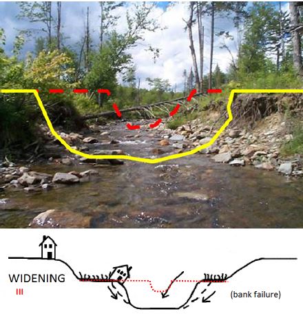
"Widening" is a stage of stream channel evolution where deeper more powerful flows begin eroding banks laterally.
SNP " Channel evolution, Stream Geomorphic Assessment, Reach, Floodplain Access, Discharge, Sediment, Aggradation, Degradation, Bedrock (Ledge), Armoring, Berm, Flood, Flood chute