
Beyond next year and over future decades our friends, family and children may be living here. What will help them thrive and what will reduce the cycle of misery and setbacks due to flooding and avoidable hazards?
Some communities are already fairly flood resilient. Others have a long ways to go. Your community needs to identify places where it is inappropriate to develop but likewise you should flag places to promote future growth. In your municipal plan your community articulates a shared vision of the place and values you cherish and strive to accomplish. Where are the places where these goals and values cohere in a vision of your community in the decades ahead?
After Tropical Storm Irene, the EPA Smart Growth Implementation Assistance Program (SGIA) worked with the State of Vermont and communities in the Mad River watershed and published a summary of opportunities for long-term flood resilience planning.
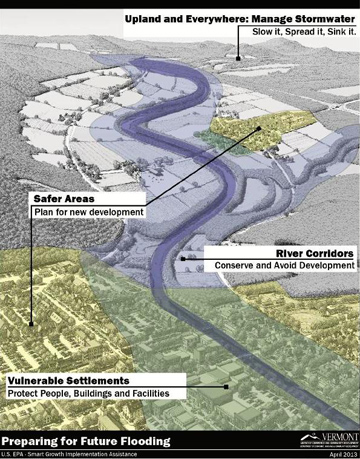 The graphic to the right identifies the four primary elements of the guidance.
Links to sections below:
- Map buildable and developable lands
- Develop a plan for new development and redevelopment
- Adopt policies to encourage development in safer locations
- More resources
Map buildable and developable lands
Work with a GIS professional such as at the Regional Planning Commission to gather the best available information about your community’s landscape. Look at the data together to identify the areas with least physical constraints, lowest long-term costs, and optimum outcomes for your community.
- Consult your community’s regulations, goals, values, and vision;
- Identify areas to protect (river corridors, floodplains, wetlands, forested areas, historic resources, aquifers, public water supplies, potential public water supplies, critical habitat);
- Identify hazardous areas (steep soils, landslide risk, marine clays);
- Identify places that may be redeveloped or remediated (brownfield sites)
- Identify existing assets (transportation, water supplies, wastewater systems, energy, communications infrastructure, public investments and critical services);
- Create a map showing optimum buildable and developable areas
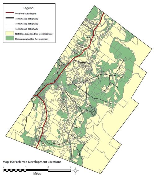 In 2012 the Town of Waitsfield used this type of process to support the town plan with a map of areas recommended for development.
Develop a plan for redevelopment
With information about the opportunities in your community bring residents, property owners, and other stakeholders together to review the community goals and develop a vision and physical plan for how the community can focus redevelopment in these safer locations.
In Vermont many communities have significant physical constraints and small populations. A recent planning process used for Adirondack hamlets may offer some suggestions about a physical planning process; particularly Chapter 5 on expansion.
Look at the Resilient Communities Scorecard from the Vermont Natural Resources Council as a tool to help reflect on your community’s goals and tools.
Adopt policies to encourage development in the identified safer locations
Communities change slowly for the most part but sometimes (such as after a disaster) dramatically. To establish a new pattern of development the community will need to clearly articulate its goals in the municipal plan and follow through with the regulatory and non-regulatory tools available. The first step might be to identify and eliminate any unnecessary barriers to development in the safer locations. These barriers may include street and building setbacks, density and parking requirements.
To accomplish the community’s goals, perhaps including a walkable mixed use area with transportation links, it might be necessary to plan for and invest in key infrastructure for roads, water supply and sewage treatment.
What incentives and investments can the community make to create successful development or redevelopment of these safer locations? How does this integrate with the capital program?
Think about your opportunities within the watershed and build from your strengths. The process of becoming a flood ready community will require working partnerships with other communities in your watersheds, the Regional Planning Commission, state and federal agencies, non-governmental organizations and private developers. Align your work with your partners.
Do what you can now. Your community will adapt with each step you implement. After future disasters your community will value your effort to enable safe redevelopment in alignment with the community goals, assets, and opportunities.
Be sure to review the resources and funding identified at the Vermont Planning Information Center and at the ACCD Department of Housing and Community Development website, particularly Plan Today for Tomorrow’s Flood and the opportunities identified by your Regional Planning Commission.
Municipalities can obtain benefits to improve and revitalize their existing villages and downtowns – including identifying locations for future development – through the designation programs administered by the Department of Housing and Community Development. In particular, development of homes in safer places can be planned and encouraged by designating a Neighborhood Development Area within walking distance of shops and services.
More resources
Assessing State Policy Linking Disaster Recovery, Smart Growth, And Resilience In Vermont Following Tropical Storm Irene, Gavin Smith, Dylan Sandler, and Mikey Goralnik Vermont Journal of Environmental Law 2013
Disaster Recovery and Long-Term Resilience Planning in Vermont - U.S. EPA Smart Growth Implementation Assistance Project Guidance Document for the State of Vermont August 2013
Resilient Communities Scorecard Vermont Natural Resources Council, 2013
Vermont’s Roadmap to Resilience - The Institute for Sustainable Communities (2013)
Vermont State Agency Policy Options Smart Growth Implementation Assistance Program: Disaster Recovery and Long-Term Resilience Planning in Vermont, Gavin Smith, EPA, FEMA, CHC, NHMA, 2013
Waitsfield Town Plan, Appendix 2 Maps 2012
Also, visit these pages:
Get Help - Updating Your Plans
Resources - Vermont Reports and Video Presentations
Resources - Planning Resources