

Becoming a flood resilient community and state will require considerable action on the part of all of us. Your community needs to set the direction and the priorities well beyond the requirements of the municipal plan, the incentives for ERAF and the suggestions here. Below you will find a number of resources that may open new opportunities for your work ahead.
If you become aware of something new – please post it to the Flood Resilience Listserve or let us know so more people can learn from it!
Links to sections below:
- Vermont Reports and Video Presentations
- Climate Change
- Disaster History and Tropical Storm Irene
- Watershed and Resource Information
- River Science and Policy
- Lakes and Shore Lands
- Dam Safety
- Resilience as a Framework
- Planning Resources
- Law and Policy
- Model Bylaws, Floodplain and River Corridor Regulations
- Storm Water and Natural Flood Protection
- Roads and Infrastructure
- Flood Emergency Response
- Flood - Building Cleanup
- Insure Residual Risk
- Get Help
- Map Data
- Communicating Risk
- Flood Ready Handouts
Vermont Reports and Video Presentations
Prepared for the Lake Champlain Basin Program by Milone & MacBroom in partnership with Fitzgerald Environmental Associates, Earth Economics, and dkcarlton and associates, Waterbury, VT. Schiff, R., S. Bighinatti, E. Fitzgerald, N. Wahlund, D. Carlton, A. Church, J. Lousios, and B. Cote, 2015.
Report to the General Assembly on the Current Status of the Vermont River Corridor and Floodplain Management Program and Shoreland Protection Program, 2014
ISC (8/2015) Progress Report: Vermont's Roadmap to Resilience
EPA 231-R-14-003 July 2014 (pdf 4 MB) www.epa.gov/smartgrowth
Vermont Economic Resiliency Initiative -  Agency of Commerce and Community Development (ACCD) - summarizing work in Vermont and detailed final reports for five communities.
Reports for Barre, Brandon, Brattleboro, Enosburgh and Woodstock
Protecting River Corridors in Vermont. Michael Kline and Barry Cahoon, 2010. Journal of the American Water Resources Association (JAWRA) 1-10
Rivers and Resilience: Lessons Learned from Tropical Storm Irene, David K. Mears and Sarah McKearnan Vermont Journal of Environmental Law [Vol. 14 2013]
Assessing State Policy Linking Disaster Recovery, Smart Growth, And Resilience In Vermont Following Tropical Storm Irene, Gavin Smith, Dylan Sandler, and Mikey Goralnik
Lessons from the Floods - Lake Champlain Committee
Transcript of Panel Five of the After Irene Symposium on Creating a More Resilient Vermont, Bob Irwin, Deb Markowitz, David K. Mears, and Brian Shupe 2012-2013
Report on the Viability and Disaster Resilience of Mobile Home Ownership and Parks, DHCD Dec 2013
Rapid Assessment of Flood Risk in Vermont Mobile Home Parks, Scott Hamshaw presentation (2012)
Community Recovery Partnership Report Oct 2012
River Corridor, Floodplain & Shoreland Protection Programs, Biennial Report to the General Assembly Pursuant to Act 110, VT DEC Jan. 2017
Videos on the Anniversary of Tropical Storm Irene: Stories of What Went Right
Otter Creek Floodplain Response to Irene
The Connecticut River Watershed Council and The Conservation Law Foundation have joined together to step back to look at why Otter Creek in Rutland leapt up as Irene struck, increasing in flow by nearly 20 times in the space of a little more than a day, while downstream in Middlebury the river rose much more gradually, and more safely. The film is narrated by Gov. Howard Dean.
Jenny Coolidge Brook Culvert Response Irene
CRWC and CLF also looked at the decision to install larger culverts, including near the headwaters of the West River high in the Green Mountain National Forest. One such culvert, on Jenny Coolidge Brook, still stood after Tropical Storm Irene while others near it failed, preventing a costly replacement and preventing erosion and other flood damage.
Upstream Downtown Workshop Presentations (Videos from April 8, 2013)
Resilient Waterscapes (35 min) – Urban / River Interface Designs, Herbert Dreiseitl, Atelier Dreiseitl, Landscape Architect, Loeb Fellow
Flood Resiliency and Design (35 min) - Built Structures and Rivers in Conflict, Barry Cahoon, P.E., VT ANR River Management Engineer
Event partners: Harvard Loeb Fellowship, ACCD, ANR, Vermont Planners Association, Vermont Natural Resources Council, and Vermont Chapter of American Society of Landscape Architects
Road washout, Freeport, ME August 25, 2008
Ice Release Northfield VT, Lewis Case, March 12, 2008
VT Route 125 flooding, Ripton, August 6, 2008
Lake Champlain Flood, April 20, 2011
Making it Happen - search for "videos"
Back to Top
Climate Change
Climate Change in Vermont - Vermont Agency of Natural Resources climatechange.vermont.gov
Vermont State Climate Office
Northeastern Regional Climate Center - Cornell University
NRCC Climate Change Links
Charts by State - Southern Regional Climate Center - Lousiana State University
Water Resources Dashboard for Planning - US Climate Resilience Toolkit
Back to Top
Disaster History and Tropical Storm Irene
Assessing State Policy Linking Disaster Recovery, Smart Growth, and Resilience In Vermont Following Tropical Storm Irene, Gavin Smith, Dylan Sandler, and Mikey Goralnik
Rivers and Resilience: Lessons Learned From Tropical Storm Irene, David K. Mears and Sarah McKearnan 2012-2013
Transcript of Panel Five of the After Irene Symposium on Creating a More Resilient Vermont, Bob Irwin, Deb Markowitz, David K. Mears, and Brian Shupe 2012-2013
Irene: Reflections on Weathering the Storm, Irene Recovery Office 2013 Report, Ben Rose, Katherine Ash
VPR Mapping the Money
Impact of Tropical Storm Irene on Streams in Vermont 2011, by George Springston and Kristen Underwood
VCGI Irene Data
FEMA – Flood Insurance Maps and Studies
FEMA – Disaster Declarations in Vermont
GenDisasters: Vermont Disasters
NWS Recent Weather Events
NOAA Storm Events Database (State/County/Town)
NWS Flooding in Vermont
Spatial Hazard Events and Losses Database for the US (SHELDUS)
UVM Landscape Change Program
Letter from Allen Wheeler regarding the flood of Nov. 1927 UVM Alum1930
USGS Chronology of major and other memorable floods and droughts in Vermont, 1770-1988, wsp-2375
Floodplains Saved Middlebury $1.8M in Damage, Kari Byran Watson, Gund Institute, UVM
Watershed and Resource Information
Flood Ready Atlas – River Corridor and Floodplain Maps
Vermont ANR Natural Resource Atlas
Water Resources Dashboard for Planning - US Climate Resilience Toolkit
USGS StreamStats for Vermont
USGS Version 3 Beta - for Vermont (custom data for watersheds - size, precipitation, flood discharges, percent impervious surface)
USGS WaterWatch
USGS RealTime Stream Flows
USGS Data Links for Vermont
NWS National Water Prediction Service and Inundation Mappers
- VT/ BTV: https://water.noaa.gov/wfo/btv
- Johnson: https://water.noaa.gov/gauges/JONV1
- Montpelier https://water.noaa.gov/gauges/MONV1 (and Inundation Map)
- Waterbury https://water.noaa.gov/gauges/WATV1 (and Inundation Map)
- All VT Gauges https://water.noaa.gov/area/BTV#river21
VT DEC Water Quality Tactical Basin Planning
VT DEC Wetlands Program
VT DEC River Corridor Plans and Final Reports
Dam Inventory Vermont Natural Resource Atlas (many larger high hazard dams have Emergency Action Plans)
Vermont Geological Survey Stream Geomorphology
Streamflow Changes after Forest Clearing in New England; Hornbeck, J.W., R.S. Pierce, and C.A. Federer Water Resources Research, 6(4):1124-1132
Impact Matrix: Geomorphic and Hydrologic Adjustments Response due to Land Use Changes
Basin Plans and Water Quality Resources
Vermont Geological Survey Final Report for Watershed Hydrology Protection and Flood Mitigation: Phase One 1/15/98
Effects of Urban Development on Floods, C. P. Konrad, USGS Fact Sheet 076-03
Urbanization and Streams: Studies of Hydrologic Impacts EPA
Case Studies - impacts that increased flow due to urbanization - EPA
The Role of Trees and Forests in Healthy Watersheds: Managing Stormwater, Reducing Flooding, and Improving Water Quality, Penn State Extension
Back to Top
River Science and Policy
Protecting River Corridors in Vermont. Michael Kline and Barry Cahoon, 2010. Journal of the American Water Resources Association (JAWRA) 1-10
Why We Continue to Develop Floodplains: Examining the Disincentives for Conservation in Federal Policy 2017 Zachary Christin, Earth Economics and Michael Kline, Vermont Rivers Program Manager, VTDEC
ASFPM Riverine Erosion Hazards White Paper (Feb 2016)
ASFPM Natural and Biological Functions of Floodplains
ASFPM Flood Science Center - Research, Resources, Projects
Supporting New England Communities to Become River-Smart: Policies and Programs that can Help New England Towns Thrive Despite River Floods, 9/2016 Eve Vogel and UMass Amherst RiverSmart extension.umass.edu/riversmart
Giving Our Rivers Room to Move: A New Strategy and Contribution to Protecting Vermont's Communities and Ensuring Clean Water, Vermont Journal of Environmental Law [Vol. 17 pp.734-765] Vermont Journal of Environmental Law Vol 17.
VT DEC Rivers Management Program
Flood Hazard Area & River Corridor Protection Procedure
Flood Hazard Area & River Corridor Rule
River Corridor Plans and Geomorphic Assessments
The Active River Area: A Conservation Framework for Protecting Rivers and Streams, The Nature Conservancy – 4/2008
Reconnecting Rivers to Floodplains: Returning natural functions to restore rivers and benefit communities, American Rivers - Spring 2016
Reading Rivers, VNRC 2013 (Recent overview of issues and best practices)
Living in Harmony with Streams: A Citizen's Handbook to How Streams Work, Friends of the Winooski, 2016, 2012
Ottauquechee Natural Resources Conservation District (ONRCD) Stream Table Demonstrations and River River Roadshow
CRREL Ice Jam Database
Precipitation Records - Wunderground Historical Weather
Quantifying flood mitigation services: The economic value of Otter Creek wetlands and floodplains to Middlebury, VT, Ecological Economics
Volume 130, October 2016, Pages 16–24 Keri B. Watson, Taylor Ricketts, Gillian Galford, Stephen Polasky, Jarlath O'Niel-Dunne
Riparian Buffer Restoration - 11 Webinars - Penn Clean Water Academy
Lakes and Shorelands
Vermont Lakeshores and Lake Wise
Vermont Shoreland Permit Program
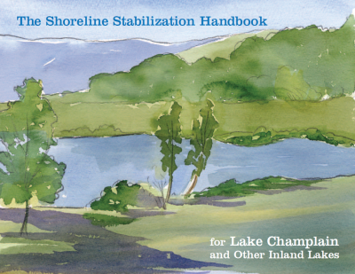
NRPC Shoreline Stabilization Handbook for Lake Champlain and Other Inland Lakes
Floodplains Key to the Health of Lake Champlain White Paper
Flood-inundation maps for Lake Champlain in Vermont and in northern Clinton County, New York; Flynn, Robert and Laura Hayes, SIR 2016-5060
Assessment of the spatial extent and height of flooding in Lake Champlain during May 2011, using satellite remote sensing and ground-based information: U.S. Geological Survey Scientific Investigations Report 2014–5163, 18 p. Bjerklie, D.M., Trombley, T.J., and Olson, S.A., 2014,
High-water marks from flooding in Lake Champlain from April through June 2011 and Tropical Storm Irene in August 2011 in Vermont: U.S. Geological Survey Data Series 763, 11 p. Medalie, Laura, and Olson, S.A., 2013,
USGS Lake Champlain Lake Level - Sign up for Water Level Alerts
In 2020 the International Joint Commission Study Board (IJC) released four short videos (vimeo) about the study and recorded presentations:
- Causes and Impacts of Flooding
- Flooding Myths
- Storing Flood Waters
- Structural Mitigation Measures in the Richelieu River
- Technical Webinar: How the LCRR is assessing Climate Change
- Technical Webinar: Development of a Performance Indicator for Damages
- Technical Webinar: Improvements in Forecasting
- Technical Webinar: Watershed Storage
Dam Safety
Association of State Dam Safety Officials / Know Your Risks www.livingneardams.org
- Living with Dams: Know Your Risks - e-book, pdf
- Extreme Rainfall Events - e-book, pdf
Vermont DEC Dam Safety Program
Living With Dams: Know Your Risks FEMA
Dam Safety Website FEMA
Recorded ASFPM Webinar: Know Your Dam Risk (requires Adobe Flash)
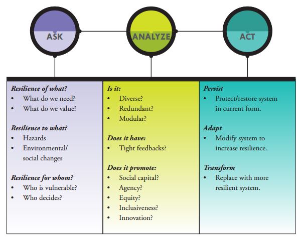
Resilience as a Framework
Bounce Forward: Urban Resilience in the Era of Climate Change - Island Press and Kresge Foundation
an exceptional discussion of the conceptions of resilience, with an integrated framework and tools.
Organizations Addressing Resilience and Sustainability (OARS) - a resource set curated by Don Watson for the Natural Hazards Mitigation Association
The Patchwork Quilt - Natural Hazards Mitigation Association
100 Resilient Cities Initiative - Rockefeller Foundation
Back to Top
Planning Resources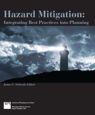
MainStreet.org - Disaster and Resilience Toolkit
Vermont Planning Information Center VPIC (including guidance on the legal process for municipal plans)
Plan Today for Tomorrow's Flood ACCD
Flood Resilience Checklist for Vermont Communities, ACCD
Vermont State Agency Policy Options Smart Growth Implementation Assistance Program: Disaster Recovery and Long-Term Resilience Planning in Vermont, Gavin Smith, 2013
Vermont’s Roadmap to Resilience 2013 ISC
Rebuilding Stronger – Learning from the Mad River Watershed (2013) EPA ACCD
Vermont Economic Resiliency Initiative (VERI) ACCD
Report on the Viability and Disaster Resilience of Mobile Home Ownership and Parks, DHCD Dec 2013
Resilient Communities Scorecard VNRC 2013 (Planning For Climate Change and Energy Disruption)
Understanding stakeholder preferences for flood adaptation alternatives with natural capital implications. Loos, J.R., and S.H.Rogers. 2016 Ecology and Society 21(3):32
Natural Hazards Center - University of Colorado at Boulder
Resilient Neighbors Network - NHMA
No Adverse Impact – ASFPM
Naturally Resilient Communities - Using Nature to Address Flooding - Nature-based solutions, resources, funding
Hazard Mitigation: Integrating Best Practices into Planning, American Planning Association, 2010
Floodplain Buyouts: An Action Guide for Local Governments on How to Maximize Community Benefits, Habitat Connectivitiy, and Resilience UNC April 2017
Planning for Post-Disaster Recovery: Next Generation (PAS 576), American Planning Association, 2015
FEMA Public Survey Info on Flood Risk
NOAA Hazard and Resiliency Planning: Perceived Benefits and Barriers Among Land Use Planners 2010
Natural Capital Project - The Nature Conservancy
Planning - Climate Change UK Cities
Vermont State Statutes 24 VSA Chapter 117
Rivers, Trails, and Conservation Assistance Program - National Park Service
FEMA Flood Risk Communication Video Series - Youtube
FEMA Map Update related Videos.pdf with link to the Youtube channel.
Law and Policy
Preparing for the Next Flood: Vermont’s Floodplain Management 2009, Vermont Law School
VT DEC River Corridor and Floodplain Protection Program
Legal Papers - Association of State Floodplain Managers
Government Liability and Climate Change: Selected Legal Issues, Review Draft 6.12.14, Dr Jon Kusler, Esq
Back to Top
Model Bylaws, Floodplain and River Corridor Regulations
Vermont DEC has prepared model regulations for communities to work with. They have been pre-reviewed by FEMA and meet or exceed the requirements of the National Flood Insurance Program.
In addition, adoption and enforcement of Section D, River Corridors, qualifies communities for enhanced cost share under the Emergency Relief and Assistance Fund.
Contact your DEC Regional Floodplain Manager if you have questions or would like a Word version of the text for editing.
Storm Water and Natural Flood Protection
Vermont DEC Stormwater Program
Low Impact Development: Planning and Policy
Model Low Impact Development Bylaws VLCT
Model Riparian Buffer Ordinance VLCT
Low Impact Development Review Checklist – Guilford, Connecticut
Green Infrastructure Collaborative - Lake Champlain Sea Grant Program and VT DEC
Green Infrastructure Initiative YouTube Channel
Importance of Trees in Stormwater Management
Water Quality and Stormwater
Community Strategies for Vermont’s Forests and Wildlife: A Guide for Local Action, VNRC 8/2013
EPA Green Infrastructure
Otter Creek Wetlands Floodplain and Middlebury Study - News 7/8/2016
Roads and Infrastructure
VTrans Orange Book: A Handbook for Local Officials
VTrans Online Bridge and Culvert Inventory Tool
VT DEC Stream Geomorphic DMS Bridge and Culvert Database
Vermont Culvert Aquatic Organism Passage Screening Tool, March 2009
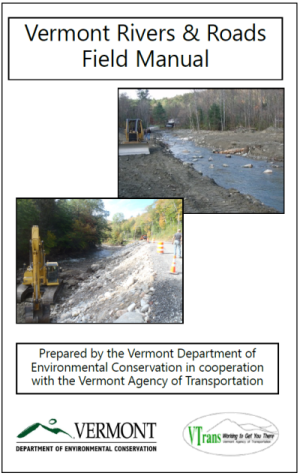
Rivers and Roads Field Guide, booklet form
Rivers and Roads Tier One Training
Tier Two Overview
Back to Top
Flood Emergency Response
VEM Daily Situation Report
VT-Alert
Vermont Emergency Management (VEM)
Vermont Local Emergency Operations Planning
Municipal Guidance for Flood Emergencies in Vermont - Windham Regional Commission and UMass 8/2016
VT/ BTV: https://water.noaa.gov/wfo/btv
Johnson: https://water.noaa.gov/gauges/JONV1
Montpelier https://water.noaa.gov/gauges/MONV1
Waterbury https://water.noaa.gov/gauges/WATV1
All VT Gauges https://water.noaa.gov/area/BTV#river21
NWS - Northeast Regional River Forecast Center
NWS - Flood Safety
NOAA Interactive Snow Information
Cold Regions Research and Engineering Lab (CRREL) Ice Jam Database
USGS Water Alerts Also, here: automatic updates on flows from USGS gauges
Vermont DEC - River Management Program
Municipal Guide to Authorizing Instream Emergency Protective Measures in Vermont
Municipal Online Reporting of Instream Emergency Protective Measures / Stream Alterations Contact Form
Emergency Protective Measures - List of Authorized Measures
Back to Top
Flood - Building Clean Up
Caution: after a flood the clean up process can be very important, complex and daunting. Promptly draining and drying the structure is important. Photograph the condition of the buildling condition and contents - particularly for insurance purposes. Contact your insurance agent and get an adjuster scheduled. Contact the community's flood hazard administrator to determine what emergency building repairs can proceed. Determine if the building is safe to work around or in. If a building has sustained considerable damage from any cause it will need to be assesed by the community flood hazard administrator to see if it sustained "substantial damage". Some kinds of insurance funding (ICC) or grant funding (HMGP) is based on the substantial damage assessment. In rare disasters funding may become available for individuals and households (IHA) for losses that could not be insured and loans may become available through the Small Business Administration.
Here are some helpful links for the physical clean up process:
Flood Preparedness (Before, During, After) Checklist - Agility Recovery on VLCT
Re-entering Your Flooded Home - CDC
Cleaning Up Your Home After A Flood - Improvenet - with many helpful links
Cleaning Up After a Flood - FEMA
Cleaning Flooded Buildings - FEMA
Managing Disaster-Generated Debris - USACE on VLCT
Hazardous materials separation - flyer
Mold After a Disaster - CDC
Repairing Your Flooded Home - American Red Cross
What Could A Flood Cost - NFIP/FEMA www.Floodsmart.gov
Back to Top
Insure Residual Risk
Topical Handouts from Two Rivers-Ottauquechee Regional Commission
- Floodplain Basics
- Protecting Property Rights to Reduce Liability
- Living with Inadequate Maps
- Using Freeboard and Setbacks to Reduce Damage
- No Adverse Impact Floodplain Management
- Protecting Lives and Property through the NFIP Community Rating System
FloodSmart.gov FEMA Flood Insurance Information for Consumers
FEMA National Flood Insurance Program (NFIP)
FEMA Flood Insurance Reforms (BW 2012, HFIAA)
ASFPM – On the Biggerts-Waters Act and Affordability
FEMA Community Rating System (CRS)
Montpelier CRS Flood Information Page
Vermont DEC Contact for CRS Information
Back to Top
Map Data
Flood Ready Atlas - web-based map with river corridor, special flood hazard area and other data
Flood Hazard Mitigation Buyout / Acquistion Map - TRORC 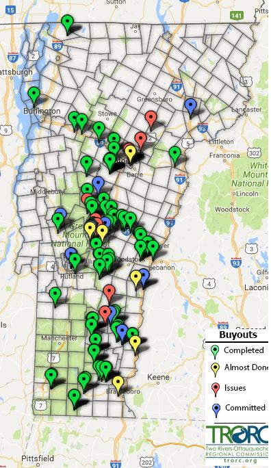
FEMA Map Service Center - web-based map and access to official Flood Insurance Rate Map data
Flood maps for the Winooski River in Waterbury, Vermont, 2014: Olson, S.A., 2015, U.S. Geological Survey Scientific Investigations Report 2015–5077
USGS Flood Inundation Mapper – for Waterbury, VT
Flood recovery maps for the White River in Bethel, Stockbridge, and Rochester, Vermont, and the Tweed River in Stockbridge and Pittsfield, Vermont, 2014, Scientific Investigations Report 2015-5056
Analysis of floods, including the tropical storm Irene inundation, of the Ottauquechee River in Woodstock, Bridgewater, and Killington and of Reservoir Brook in Bridgewater and Plymouth, Vermont Robert H. Flynn, Scientific Investigations Report 2014-5214 Prepared in cooperation with the U.S. Army Corps of Engineers
Flood inundation maps and water-surface profiles for tropical storm Irene and selected annual exceedance probability floods for Flint Brook and the Third Branch White River in Roxbury, Vermont Elizabeth A. Ahearn and Pamela J. Lombard, Scientific Investigations Report 2014-5118 Prepared in cooperation with the U.S. Department of Homeland Security Federal Emergency Management Agency
Annual exceedance probabilities of the peak discharges of 2011 at streamgages in Vermont and selected streamgages in New Hampshire, western Massachusetts, and northeastern New York Scott A. Olson, Gardner C. Bent 2013, Scientific Investigations Report 2013-5187
High-water marks from flooding in Lake Champlain from April through June 2011 and Tropical Storm Irene in August 2011 in Vermont Laura Medalie, S.A. Olson 2013, Data Series 763
Assessment of the spatial extent and height of flooding in Lake Champlain during May 2011, using satellite remote sensing and ground-based information David M. Bjerklie, Thomas J. Trombley, Scott A. Olson 2014, Scientific Investigations Report 2014-5163
Estimation of flood discharges at selected annual exceedance probabilities for unregulated, rural streams in Vermont, with a section on Vermont regional skew regression Scott A. Olson, Andrea G. with a section by Veilleux 2014, Scientific Investigations Report 2014-5078
Vermont Center for Geographic Information - web-based maps and GIS data
VCGI Interactive and Static Maps
Back to Top
Communicating Risk
Critical Issues Research Database (American Geosciences Institute) including reports and factsheets about flood risk.
It’s Time To Ditch The Concept Of ‘100-Year Floods’, Maggie Koerth FiveThirtyEight
Flood Ready Handouts
Flood Ready Handout - set up as four "cards" on an 8.5 x 11" page. Print double sided to flip on short edge.
More handouts at: floodready.vt.gov/info