
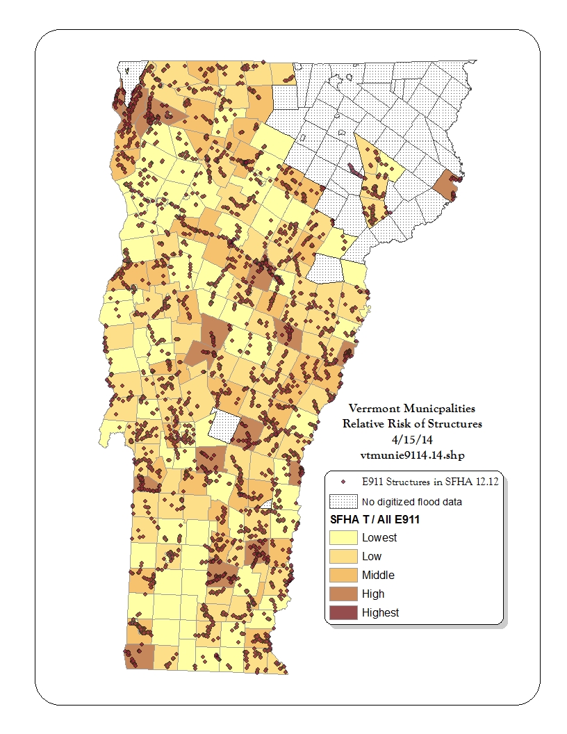
 Vermont has been settled in diverse patterns reflecting opportunities and cultures. In some locations, and in the absence of information about flood risk (or germ theory for that matter) settlements have evolved near attractive constraints (bridges), water power (mill sites), or shore lands. Today, over ten thousand structures in Vermont are currently in the Special Flood Hazard Area.
Many communities cherish their historic villages and features and are concerned about how to prepare for the future. What options are available? What works best?
Links to sections below:
- Protect what’s working
- Promote safer places
- Examine your options
- Restore and enhance
- Relocate and elevate
- Historic buildings
- Communities exploring options
- Vermont Economic Resiliency Initiative (VERI)
Protect what’s working
Your community’s Flood Insurance Study, community histories and sources like the UVM Landscape Change program may identity ways in which floods have already shaped the settlement patterns in your community. Flooding has repeatedly destroyed mills and settlements particularly when there was extensive deforestation uphill and rivers were straightened for log transport, drainage, and to accommodate rail lines. Barry Cahoon speaks to this history in Vermont Downtowns and Flooding (video). The most important step now is to understand your vulnerable settlement in the context of its watershed and the assets that are working to moderate flood peaks. Has your community protected those assets? What can it do to restore those functions?
 Promote safer places
While your vulnerable settlement is an important asset – it does not mean that future development needs to be placed in harm’s way. Identify the safer locations for future development and redevelopment. Locate your critical facilities and key services in places where they will function when needed.
Examine your options
Having protected your watershed assets and secured your critical functions, the settlement may still be in an area subject to repeated inundation, affected by powerful erosive forces, sedimentation, or ice jamming. This is a time to step back and look at the situation in the context of the watershed and river corridor to identify restoration and other response opportunities.
Communities such as Jeffersonville and Waterbury (see links below) have initiated data-driven examinations of flood mitigation options. Three Mad River valley communities, Fayston, Waitsfield and Moretown, have worked with EPA’s Smart Growth Implementation Assistance to also identify planning recommendations for vulnerable settlements.
Restore and enhance
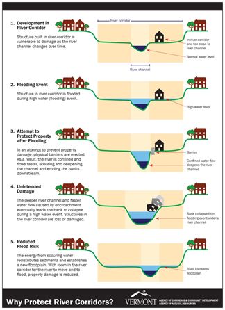
Seventy-five percent of rivers in Vermont have been pushed out of equilibrium condition. When rivers are narrowed, confined and straightened the energy becomes trapped within the channel and the stream bed gets scoured out. During high flows the water no longer spills out onto the river’s floodplain. The confined flow is more powerful and digs yet further into the river bed and accelerates bank erosion.
If the condition upstream can be brought back into geomorphic equilibrium there will be more access to floodplain above the settlement and a less damaging peak flow arriving to cause damage. Sometimes there are a few opportunities to restore some floodplain access even within the settled area: removing particularly vulnerable buildings, increasing flood storage and perhaps creating an attractive connection to the river that might also create a cultural asset for the community.
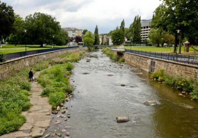
In April 2013 Montpelier hosted the Upstream Downtown presentations from the Loeb Fellow landscape architects. The Upstream Downtown Workshop – Making room for the river and building resiliency in Vermont’s downtowns and villages looked at situations in Waterbury and Montpelier and explored creative ways that these communities could choose to re-orient toward their river features. During the economic period when many brick communities were built the rivers were dangerous places used for sewage and industrial waste conveyance. Today, forty years after the Clean Water Act the river features are often still under-utilized assets for many settlements. Hazard reduction and floodplain restoration may complement other community priorities such as connections to greenways, rail trails, and establishing public gathering spaces.
Herbert Dreisetl, a landscape architect and one of the Loeb Fellows presented examples of new urban river interface designs in Europe. Resilient Waterscapes (35 min)
Relocate and Elevate
Within the settlement itself there may be steps that can be taken to reorient the settlement to the river and by making changes building by building. Looking at mapped Special Flood Hazard Areas and river corridors you may find that some structures are affected by multiple stressors. Along some rivers FEMA has prepared detailed studies and identified Floodways. Floodways are areas that protect a right-of-way for floodwater movement and these areas often coincide with particularly dangerous high velocity flows. Structures in this area should get a high priority for acquisition or relocation.
Under new FEMA rules (2013) for Hazard Mitigation Grants any structure in the Special Flood Hazard Area (including the Floodway) is eligible for acquisition or elevation funds without having to document a past history of loss. The FEMA Hazard Mitigation Grant program will pay 75% of the cost to acquire a structure if the cost is less than $276,000 or to elevate the lowest floor if the cost is less than $175,000. The community needs to have a Local Hazard Mitigation Plan in place to receive these funds. Contact your Regional Planning Commission for more information. If the cost of the project is above the thresholds a Benefit-Cost Analysis will be required.
 On a building-by-building basis it is also important to factor in the risk of damage to the building, contents and the cost of insuring such risk. Flood insurance is required for the value of any mortgage or loan to a building in the Special Flood Hazard Area. The cost of flood insurance reflects the value of the structure and/or contents, the presence of a basement, and the elevation of the bottom floor (the basement is the bottom floor).
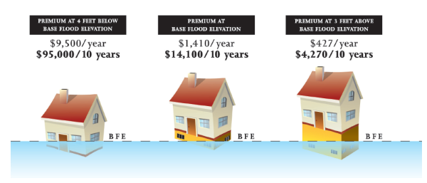
In 2012 and 2014 Congress made changes to the National Flood Insurance Program and in both cases indicated that the cost of flood insurance should pay for the true risk. This cost can have a major effect on the ability of someone to finance a building. Currently most structures in the Vermont high risk area do not have flood insurance and will have no significant compensation from a homeowners’ insurance policy after a flood. Most structures in the hazard area in Vermont are older “Pre-FIRM” structures that do not have Elevation Certificates documenting the elevation of the bottom floor relative to the elevation of the base flood water (BFE). The community may be able to help people secure such data by cooperating as a neighborhood group to hire a surveyor, or by establishing a local vertical benchmark.
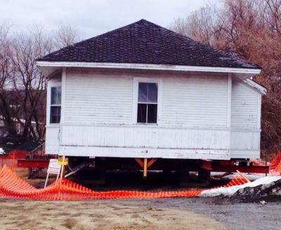
If the owner of a building in the flood hazard area can convert a basement into a flood-vented crawlspace the cost of flood insurance can be reduced by hundreds of dollars a year. If the structure’s walk-in level floor is also below the base flood elevation and can be elevated one or more feet above the flood water – the cost of flood insurance drops enormously and the work may be eligible to get 75% funded by a Hazard Mitigation Grant! The Village of Waterbury is currently working on a pilot project to elevate several structures in the Special Flood Hazard Area. Contact the Waterbury Long Term Community Recovery project to learn more.
In addition to FEMA Hazard Mitigation Grants, communities may also want to consider applying for a Community Development Block Grant (CDBG) from Housing and Urban Development (HUD).
Non-residential buildings in the Special Flood Hazard Area may be flood-proofed in most communities. Dry flood proofing requires considerable structural support, careful engineering and implementation and still often fails in implementation. The community of Lincoln secured a FEMA Hazard Mitigation Grant to flood-proof the Burnham Memorial Hall. Here is a seven-minute video Mitigation Works describing this project in Lincoln and FEMA’s recent work with historic structures in Vermont.
Peg Elmer of Community-Resilience.org initiated a charrette in 2013 to look for creative adaptations for buildings to improve their protection from damage. The project looked at sites both inside the high risk Special Flood Hazard Area and outside. The findings of the charrette are published in the Property Owner’s Guide to Re-Building for Flood Resiliency Feb 2014
The work of modifying buildings is complex. The effort includes assessment (getting elevation information, understanding municipal permit requirements, considering designs and insurance outcomes), financing and contracting. The experience of other people who are doing this work may be invaluable. A list serve has been established to create a mutual-support opportunity for people considering building relocation and elevation projects. If you are working to adapt a building you may want to participate in the Flood Safe Listserve.
Historic Buildings
Some vulnerable settlements include historic districts and buildings. For these historic assets it is particularly important that their risk is not increased by any further loss of existing natural flood protection in the watershed.
The National Flood Insurance Program gives special consideration to historic properties and if communities so choose in their bylaw:
- Permits are required for work on historic structures in the Special Flood Hazard Area. Many steps can also be taken by the owners of historic buildings to make them safer from damage, be more insurable and to contribute to the community as historic structures. Historic structures are not exempt from permitting related to repairs and improvements including fuel tanks, utilities, and materials.
- In many towns designated historic structures that are Substantially Damaged or Substantially Improved may not be required to elevate their lowest floor above the flood level (or Design Flood Elevation), as long as the building maintains its historic structure designation; and
- At this time there is no flood insurance subsidy for older “Pre-FIRM” structures so, while designated historic structures can obtain flood insurance, the premiums to insure the building and contents is rated according to the full risk and the steps that owners have been taken to reduce the risk of damage.
Many older and historic buildings have a basement of some type. Basements add a great deal to the cost of flood insurance because they can collect flood water and because the basement floor counts as the bottom floor for insurance rating. In some buildings it may be possible to fill in the basement and make it into a flood-compliant crawlspace without violating the historic qualities of the structure or the district. It may even be possible to elevate the walk-in level without losing the historic significance of the structure or degrading its contribution to the district.
If your vulnerable settlement includes historic buildings, it would be best to talk this through as a community before a crisis. Become familiar with methods to reduce flood damage in ways that are most compatible with preserving your historic resources. In some places it may help to have a qualified historic preservationist examine the structure to provide guidance on compatible options. This learning process can inform your community plans, regulatory process and help the owners of buildings act in a timely way.
For more information on historic buildings, please send an email to ACCD.ProjectReview@vermont.gov
Vermont Division for Historic Preservation
Before You Repair Flood Damage: Important Information for Historic Building Owners and Municipalities ACCD DEC 2011
Grants and Financial Incentives for Historic Preservation in Vermont
Funding Directory for Historic Preservation Projects in Vermont
Integrating Historic Property and Cultural Resources Considerations into Hazard Mitigation Planning (FEMA-386-6)
Treatment of Flood-Damaged Older and Historic Buildings - National Trust for Historic Preservation
Floodplain Management Bulletin on Historic Structures (FEMA TB – 467) 2008
After the Flood - Heritage Preservation: the National Institute for Conservation
10 Tips for Bringing Historic Properties Back from a Flood
Treatment of Flood-Damaged Older and Historic Buildings
Communities exploring options
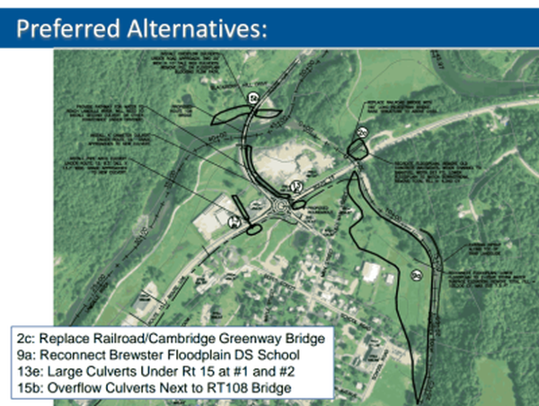
The villages of Jeffersonville and Waterbury both suffered extensive damage in 2011 from different storm events. In the wake of these experiences, and other recent events, they both pursued data-driven assessments of their exposure to damage and to weigh the most effective options to mitigate future damage.
Jeffersonville, Vermont Final Report Hazard Mitigation Plan Modeling Study - Milone & MacBroom, Inc. Jan. 2014 Powerpoint as pdf
Technical Report Jeffersonville Hazard Mitigation Plan Flood Hazard Modeling and Project Identification, Final, Prepared by Milone & MacBroom, Inc. for Lamoille County Planning Commission, March 2014
Study: Riverbank erosion increased Irene flooding Kristen Fountain, Waterbury Record Feb. 21. 2013
Winooski Street Bridge Restriction Study 12.10.13 for the Village of Waterbury
These assessments can inform the municipal plan, the Local Hazard Mitigation Plan and allow the community to pursue significant funding through FEMA Hazard Mitigation Grants or Community Development Block Grants.
Vermont Economic Resilience Initiative (VERI) worked with five communities to support local hazard assessments, plans and flood resiliency initiatives. The learning in these places will provides important models for communities around Vermont to help us manage risks from natural hazards and build back stronger and safer after disasters. VERI was funded by the US Department of Commerce’s Economic Development Administration. ACCD led this project in partnership with communities, Regional Planning Commissions, VTrans and ANR.
VERI estalished community strategies to address flood risks. The VERI site also includes resources for Continuity of Operations planning for communities and businesses.